
ᱨᱮᱫ:Arctic.svg

Size of this PNG preview of this SVG file: ᱔᱗᱘ × ᱕᱙᱙ ᱯᱤᱠᱥᱮᱞ. ᱮᱴᱟᱜ ᱨᱤᱡᱚᱞᱩᱥᱚᱱᱥ: ᱑᱙᱑ × ᱒᱔᱐ ᱯᱤᱠᱥᱮᱞ | ᱓᱘᱓ × ᱔᱘᱐ ᱯᱤᱠᱥᱮᱞ | ᱖᱑᱓ × ᱗᱖᱘ ᱯᱤᱠᱥᱮᱞ | ᱘᱑᱗ × ᱑,᱐᱒᱔ ᱯᱤᱠᱥᱮᱞ | ᱑,᱖᱓᱔ × ᱒,᱐᱔᱘ ᱯᱤᱠᱥᱮᱞ | ᱕᱐᱕ × ᱖᱓᱓ ᱯᱤᱠᱥᱮᱞ
ᱟᱥᱚᱞ ᱨᱮᱫ (SVG ᱨᱮᱫ, ᱱᱚᱨᱢᱟᱞᱛᱮ ᱕᱐᱕ x ᱖᱓᱓ pixels, ᱨᱮᱫ ᱡᱟᱜᱟ: ᱑.᱕ MB)
ᱢᱩᱬᱩᱛ ᱠᱟᱛᱷᱟ
| ᱵᱤᱵᱚᱨᱚᱱᱤ |
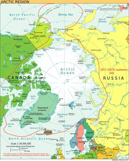
English: A view of the Arctic. The 10 °C (50 °F) mean isotherm in July line, displayed red, is commonly used to define the border of the Arctic region. |
| ᱢᱟᱹᱦᱤᱛ | ᱯᱷᱮᱵᱽᱨᱩᱣᱟᱨᱤ ᱒᱐᱑᱓ (original upload date) |
| ᱯᱷᱮᱰᱟᱛ | CIA World Factbook |
| ᱚᱱᱚᱞᱤᱭᱟᱹ | CIA World Factbook |
| Other versions |
[]
|


.svg)


|
This SVG file contains embedded text that can be translated into your language, using any capable SVG editor, text editor or the SVG Translate tool. For more information see: About translating SVG files. |
ᱞᱟᱭᱥᱮᱱᱥ ᱛᱮᱭᱟᱨ
This image is in the public domain because it contains materials that originally came from the United States Central Intelligence Agency's World Factbook.
|
 |
ᱨᱮᱫ ᱨᱮᱭᱟᱜ ᱱᱟᱜᱟᱢ
ᱚᱠᱛᱚ ᱨᱮ ᱞᱤᱱ ᱢᱮ/ᱚᱠᱛᱚ ᱨᱮ ᱨᱮᱫ ᱧᱮᱞ ᱞᱟᱹᱜᱤᱛ ᱞᱤᱱ ᱢᱮ
| ᱢᱟᱹᱦᱤᱛ/ᱚᱠᱛᱚ | ᱴᱤᱯ | ᱡᱚᱠᱷᱟ | ᱵᱮᱵᱷᱟᱨᱤᱭᱟᱹ | ᱠᱟᱛᱷᱟ | |
|---|---|---|---|---|---|
| ᱱᱤᱛᱚᱜ | ᱒᱑:᱐᱐, ᱑᱑ ᱚᱜᱚᱥᱴ ᱒᱐᱒᱓ | | ᱕᱐᱕ × ᱖᱓᱓ (᱑.᱕ MB) | Mahagaja | correct spelling of Kangiqliniq |
| ᱑᱘:᱒᱙, ᱙ ᱚᱜᱚᱥᱴ ᱒᱐᱐᱙ |  | ᱕᱐᱕ × ᱖᱓᱓ (᱑.᱕ MB) | Ysangkok | compact code, no visible changes afaik | |
| ᱒᱓:᱓᱔, ᱑᱙ ᱚᱜᱚᱥᱴ ᱒᱐᱐᱗ |  | ᱕᱐᱕ × ᱖᱓᱓ (᱑.᱖᱓ MB) | StephenHudson | Reverted to earlier revision | |
| ᱒᱒:᱑᱘, ᱑᱙ ᱚᱜᱚᱥᱴ ᱒᱐᱐᱗ |  | ᱑,᱐᱑᱐ × ᱑,᱒᱖᱗ (᱑.᱔ MB) | StephenHudson | Increased base pixel size to make text readable. | |
| ᱑᱗:᱑᱗, ᱒᱔ ᱡᱟᱱᱩᱣᱟᱨᱤ ᱒᱐᱐᱖ |  | ᱕᱐᱕ × ᱖᱓᱓ (᱑.᱖᱓ MB) | Moyogo | stripped useless stuff | |
| ᱒᱐:᱓᱒, ᱒᱓ ᱡᱟᱱᱩᱣᱟᱨᱤ ᱒᱐᱐᱖ |  | ᱕᱐᱕ × ᱖᱓᱓ (᱑.᱙᱕ MB) | Sanao | Arctic<br /> Origin : CIA World Factbook Category:SVG maps Category:Arctic |
ᱯᱷᱟᱭᱤᱞ ᱵᱮᱣᱦᱟᱨ
ᱞᱟᱛᱟᱨ ᱨᱮᱭᱟᱜ ᱥᱟᱦᱴᱟ ᱡᱚᱱᱚᱲᱠᱚ ᱱᱤᱭᱟᱹ ᱨᱮᱫ ᱨᱮ:
ᱡᱮᱜᱮᱛ ᱡᱟᱠᱟᱛ ᱨᱮᱫ ᱵᱮᱵᱷᱟᱨᱟᱜ
ᱱᱚᱶᱟ ᱨᱮᱫᱠᱚ ᱵᱮᱵᱷᱟᱨᱟᱠᱟᱫ ᱣᱤᱠᱤᱠᱚ :
- ace.wikipedia.org ᱨᱮ ᱵᱮᱣᱦᱟᱨ
- ady.wikipedia.org ᱨᱮ ᱵᱮᱣᱦᱟᱨ
- af.wikipedia.org ᱨᱮ ᱵᱮᱣᱦᱟᱨ
- ar.wikipedia.org ᱨᱮ ᱵᱮᱣᱦᱟᱨ
- arz.wikipedia.org ᱨᱮ ᱵᱮᱣᱦᱟᱨ
- ast.wikipedia.org ᱨᱮ ᱵᱮᱣᱦᱟᱨ
- as.wikipedia.org ᱨᱮ ᱵᱮᱣᱦᱟᱨ
- ba.wikipedia.org ᱨᱮ ᱵᱮᱣᱦᱟᱨ
- bg.wikipedia.org ᱨᱮ ᱵᱮᱣᱦᱟᱨ
- bn.wikipedia.org ᱨᱮ ᱵᱮᱣᱦᱟᱨ
- ca.wikipedia.org ᱨᱮ ᱵᱮᱣᱦᱟᱨ
- cy.wikipedia.org ᱨᱮ ᱵᱮᱣᱦᱟᱨ
- da.wikipedia.org ᱨᱮ ᱵᱮᱣᱦᱟᱨ
- da.wiktionary.org ᱨᱮ ᱵᱮᱣᱦᱟᱨ
- de.wikipedia.org ᱨᱮ ᱵᱮᱣᱦᱟᱨ
- dty.wikipedia.org ᱨᱮ ᱵᱮᱣᱦᱟᱨ
- el.wikipedia.org ᱨᱮ ᱵᱮᱣᱦᱟᱨ
- en.wikipedia.org ᱨᱮ ᱵᱮᱣᱦᱟᱨ
- Geography of Denmark
- Jan Mayen
- Svalbard
- Northern Canada
- History of Svalbard
- Contour line
- List of rivers of the Americas by coastline
- Arctic Bridge
- History of the petroleum industry in Canada (frontier exploration and development)
- Portal:Maps/Maps/Nautical
- Portal:Maps/Maps/Nautical/2
- Arctic Ocean
- Wikipedia:Graphics Lab/Map workshop/Archive/Aug 2009
- Sir James Lamont, 1st Baronet
- Arctic exploration
- User:Godsy/Portal example
- en.wikibooks.org ᱨᱮ ᱵᱮᱣᱦᱟᱨ
- eo.wikipedia.org ᱨᱮ ᱵᱮᱣᱦᱟᱨ
- eo.wiktionary.org ᱨᱮ ᱵᱮᱣᱦᱟᱨ
ᱱᱚᱶᱟ ᱨᱮᱫ ᱨᱮᱱᱟᱜ ᱵᱟᱹᱲᱛᱤ ᱡᱮᱜᱮᱛ ᱵᱮᱵᱷᱟᱨ ᱧᱮᱞ ᱢᱮ ᱾