
ᱨᱮᱫ:Armenia - Location Map (2013) - ARM - UNOCHA.svg

ᱟᱥᱚᱞ ᱨᱮᱫ (SVG ᱨᱮᱫ, ᱱᱚᱨᱢᱟᱞᱛᱮ ᱒᱕᱐ x ᱒᱕᱐ pixels, ᱨᱮᱫ ᱡᱟᱜᱟ: ᱗᱑᱓ KB)
_-_ARM_-_UNOCHA.svg)
ᱢᱩᱬᱩᱛ ᱠᱟᱛᱷᱟ
| ᱵᱤᱵᱚᱨᱚᱱᱤ |
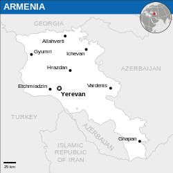
English: Locator map of Armenia. |
| ᱢᱟᱹᱦᱤᱛ | |
| ᱯᱷᱮᱰᱟᱛ |
English: Armenia Locator Map (ReliefWeb), ESRI, UNCS |
| ᱚᱱᱚᱞᱤᱭᱟᱹ | |
| SVG genesis |
ᱞᱟᱭᱥᱮᱱᱥ ᱛᱮᱭᱟᱨ
- ᱟᱲᱟᱜ ᱜᱮᱭᱟᱢ:
- ᱦᱟᱹᱴᱤᱧᱢᱮ – ᱱᱚᱠᱚᱞ ᱞᱟᱹᱜᱤᱫ, ᱦᱟᱹᱴᱤᱧ ᱟᱨ ᱵᱷᱮᱡᱟᱭᱢᱮ ᱠᱟᱹᱢᱤ
- ᱢᱮᱥᱟᱣᱠᱟᱛᱢᱮ – ᱠᱟᱹᱢᱤ ᱟᱞᱜᱟᱭ ᱞᱟᱹᱜᱤᱫ
- ᱞᱟᱛᱟᱨ ᱨᱮᱭᱟᱜ ᱨᱤᱛ ᱞᱮᱠᱟᱛᱮ:
- ᱟᱴᱨᱤᱵᱩᱥᱚᱱ – ᱟᱢ ᱠᱟᱹᱢᱤ ᱥᱚᱫᱚᱨ ᱦᱩᱭᱟᱢᱟ ᱡᱚᱠᱷᱚᱱ ᱚᱱᱚᱞᱤᱭᱟᱹ ᱟᱨᱵᱟᱝ ᱞᱟᱭᱥᱮᱸᱥᱩᱭᱟᱹ ᱫᱟᱨᱟᱭᱛᱮ ᱠᱟᱛᱷᱟ ᱨᱟᱠᱟᱵ ᱠᱷᱟᱱ (ᱢᱮᱱᱠᱷᱟᱱ ᱟᱠᱚ ᱩᱫᱩᱜᱟᱜ ᱦᱚᱨ ᱛᱮᱫᱚ ᱵᱟᱝ ᱡᱟᱦᱟᱸ ᱟᱠᱚᱠᱚ ᱜᱚᱲᱚᱣᱟᱢ ᱟᱨᱵᱟᱝ ᱟᱢᱟᱜ ᱠᱟᱹᱢᱤ ᱨᱮᱱᱟᱜ ᱵᱮᱵᱷᱟᱨ)
 This map is part of a collection of 216 free country maps, created by the UN Office for the Coordination of Humanitarian Affairs (OCHA), to be used in print, web or broadcast products.
The ReliefWeb Location Maps released here are maps that highlight a country, its capital, major populated places and the surrounding regions. Attribution Requirements
Using the map without modifications: ensure that the sources and the disclaimer are below the map. Credit as follows: "Credit: OCHA". For use with alteration: remove the OCHA logo and disclaimer following any modification to the map, but keep the data sources as mentioned below the map. Credit the modified map as follows: "Based on OCHA map". You are responsible for the content of your map. We are keen to receive your feedback and hear how you used OCHA's maps. We would be grateful if you would notify us by e-mail and share your work with us. UN Disclaimer
The designations employed and the presentation of material of this map do not imply the expression of any opinion whatsoever on the part of the Secretariat of the United Nations concerning the legal status of any country, territory, city or area or of its authorities or concerning the delimitation of its frontiers or boundaries. |

|
Textual information (e.g. timestamp) once visible in the image itself has been moved into the image metadata and/or image description page. This makes the image easier to reuse and more language-neutral, and makes the text easier to process and search for. Commons discourages placing visible textual information in images. All licenses accepted on Commons permit this type of modification as a derivative work.
If attribution information were removed and the image is not public domain, replace this tag with {{Attribution metadata from licensed image}}.
|
ᱨᱮᱫ ᱨᱮᱭᱟᱜ ᱱᱟᱜᱟᱢ
ᱚᱠᱛᱚ ᱨᱮ ᱞᱤᱱ ᱢᱮ/ᱚᱠᱛᱚ ᱨᱮ ᱨᱮᱫ ᱧᱮᱞ ᱞᱟᱹᱜᱤᱛ ᱞᱤᱱ ᱢᱮ
| ᱢᱟᱹᱦᱤᱛ/ᱚᱠᱛᱚ | ᱴᱤᱯ | ᱡᱚᱠᱷᱟ | ᱵᱮᱵᱷᱟᱨᱤᱭᱟᱹ | ᱠᱟᱛᱷᱟ | |
|---|---|---|---|---|---|
| ᱱᱤᱛᱚᱜ | ᱐᱑:᱕᱐, ᱒᱓ ᱰᱤᱥᱮᱢᱵᱚᱨ ᱒᱐᱒᱒ | | ᱒᱕᱐ × ᱒᱕᱐ (᱗᱑᱓ KB) | Wikijahnn | File uploaded using svgtranslate tool (https://svgtranslate.toolforge.org/). Added translation for ca. |
| ᱑᱓:᱓᱔, ᱙ ᱢᱟᱨᱪ ᱒᱐᱒᱒ |  | ᱒᱕᱐ × ᱒᱕᱐ (᱗᱑᱑ KB) | Nyilvoskt | File uploaded using svgtranslate tool (https://svgtranslate.toolforge.org/). Added translation for id. | |
| ᱒᱐:᱔᱓, ᱕ ᱡᱟᱱᱩᱣᱟᱨᱤ ᱒᱐᱑᱖ |  | ᱒᱕᱐ × ᱒᱕᱐ (᱗᱐᱙ KB) | Wereldburger758 | Resized page to drawing. Removal watermark. Validation of image. | |
| ᱒᱐:᱔᱖, ᱒᱔ ᱯᱷᱮᱵᱽᱨᱩᱣᱟᱨᱤ ᱒᱐᱑᱔ |  | ᱒᱕᱔ × ᱒᱕᱔ (᱗᱑᱕ KB) | Jeremyb | xslt v2b | |
| ᱒᱐:᱔᱑, ᱑᱐ ᱯᱷᱮᱵᱽᱨᱩᱣᱟᱨᱤ ᱒᱐᱑᱔ |  | ᱒᱕᱐ × ᱒᱕᱐ (᱑.᱗᱓ MB) | Pharos | {{Information |description={{en|1=Locator Map of Armenia. {{OCHA map}}}} |date=February 2014 |source=UN Office for the Coordination of Humanitarian Affairs (OCHA) |author=[[w:Unit... |
ᱯᱷᱟᱭᱤᱞ ᱵᱮᱣᱦᱟᱨ
ᱞᱟᱛᱟᱨ ᱨᱮᱭᱟᱜ ᱥᱟᱦᱴᱟ ᱡᱚᱱᱚᱲᱠᱚ ᱱᱤᱭᱟᱹ ᱨᱮᱫ ᱨᱮ:
ᱡᱮᱜᱮᱛ ᱡᱟᱠᱟᱛ ᱨᱮᱫ ᱵᱮᱵᱷᱟᱨᱟᱜ
ᱱᱚᱶᱟ ᱨᱮᱫᱠᱚ ᱵᱮᱵᱷᱟᱨᱟᱠᱟᱫ ᱣᱤᱠᱤᱠᱚ :
- az.wikipedia.org ᱨᱮ ᱵᱮᱣᱦᱟᱨ
- ca.wikipedia.org ᱨᱮ ᱵᱮᱣᱦᱟᱨ
- en.wikipedia.org ᱨᱮ ᱵᱮᱣᱦᱟᱨ
- es.wikipedia.org ᱨᱮ ᱵᱮᱣᱦᱟᱨ
- fr.wikipedia.org ᱨᱮ ᱵᱮᱣᱦᱟᱨ
- gor.wikipedia.org ᱨᱮ ᱵᱮᱣᱦᱟᱨ
- id.wikipedia.org ᱨᱮ ᱵᱮᱣᱦᱟᱨ
- ru.wikipedia.org ᱨᱮ ᱵᱮᱣᱦᱟᱨ
- so.wikipedia.org ᱨᱮ ᱵᱮᱣᱦᱟᱨ
- ts.wikipedia.org ᱨᱮ ᱵᱮᱣᱦᱟᱨ
- uk.wikipedia.org ᱨᱮ ᱵᱮᱣᱦᱟᱨ
_-_ARM_-_UNOCHA.svg)