
ᱨᱮᱫ:Map of Jalaun.png
ᱧᱮᱞᱡᱚᱝ ᱨᱮᱱᱟᱜ ᱟᱠᱟᱨ:᱗᱑᱘ × ᱕᱙᱙ ᱯᱤᱠᱥᱮᱞ ᱮᱴᱟᱜ ᱨᱤᱡᱚᱞᱩᱥᱚᱱᱥ: ᱒᱘᱘ × ᱒᱔᱐ ᱯᱤᱠᱥᱮᱞ | ᱕᱗᱕ × ᱔᱘᱐ ᱯᱤᱠᱥᱮᱞ | ᱙᱒᱐ × ᱗᱖᱘ ᱯᱤᱠᱥᱮᱞ | ᱑,᱐᱓᱐ × ᱘᱖᱐ ᱯᱤᱠᱥᱮᱞ
ᱟᱥᱚᱞ ᱨᱮᱫ (᱑,᱐᱓᱐ x ᱘᱖᱐ pixels, file size: ᱑᱒ KB, MIME type: image/png)
ᱢᱩᱬᱩᱛ ᱠᱟᱛᱷᱟ
| ᱵᱤᱵᱚᱨᱚᱱᱤ |
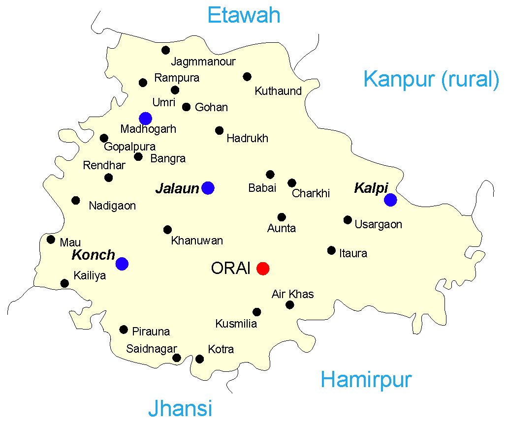
English: Map of the Jalaun district of India. I recreated this in CorelDRAW – the original was in IFC and had no information on its source. I hope I can license this under GFDL though it's derived from :Image:Map-jalaun.gif.
Legend:
sarnam pal orai
|
| ᱢᱟᱹᱦᱤᱛ | ᱒᱘ ᱥᱮᱯᱴᱮᱢᱵᱚᱨ ᱒᱐᱐᱕ (original upload date) |
| ᱯᱷᱮᱰᱟᱛ | Transferred from en.wikipedia to Commons. |
| ᱚᱱᱚᱞᱤᱭᱟᱹ | Mysid at ᱟᱝᱜᱽᱨᱮᱡᱤ ᱣᱤᱠᱤᱯᱤᱰᱤᱭᱟ |
ᱞᱟᱭᱥᱮᱱᱥ ᱛᱮᱭᱟᱨ
Mysid from en.wikipedia.org, the copyright holder of this work, hereby publishes it under the following license:
| ᱱᱚᱶᱟ ᱨᱮᱫ ᱫᱚ ᱥᱟᱫᱷᱟᱨᱚᱱ ᱥᱤᱨᱡᱟᱹᱣᱟᱜ Attribution-Share Alike 3.0 Unported ᱞᱟᱭᱥᱮᱸᱥ ᱛᱟᱹᱨᱤᱨᱮ ᱢᱮᱱᱟᱜ-ᱟ ᱾ Subject to disclaimers. | ||
| ᱟᱴᱨᱤᱵᱩᱥᱚᱱ: Mysid from en.wikipedia.org | ||
| ||
| This licensing tag was added to this file as part of the GFDL licensing update. |

|
ᱫᱟᱣ ᱮᱢᱮᱱᱟ ᱱᱚᱠᱚᱞ, ᱦᱟᱹᱴᱤᱧ ᱟᱨ/ᱟᱨᱵᱟᱝ ᱟᱹᱨᱩᱯᱷᱮᱨᱟᱣ ᱞᱟᱹᱜᱤᱫ ᱱᱚᱶᱟ ᱱᱩᱛᱷᱤ ᱠᱚ GNU Free Documentation License ᱟᱹᱨᱤ ᱛᱮ, ᱵᱷᱟᱨᱥᱚᱱ ᱑.᱒ ᱟᱨᱵᱟᱝ ᱡᱟᱦᱟᱸᱜᱮ ᱛᱟᱭᱚᱢᱟᱜ ᱵᱷᱟᱨᱥᱚᱱ Free Software Foundation ᱫᱟᱨᱟᱭᱛᱮ ᱩᱪᱷᱟᱹᱱ ᱟᱠᱟᱱ; ᱵᱤᱱ ᱵᱷᱮᱯᱮᱜᱮᱫ ᱦᱟᱹᱴᱤᱧ, ᱵᱤᱱ ᱥᱟᱢᱟᱝ ᱚᱞᱠᱚ, ᱟᱨ ᱵᱤᱱ ᱯᱟᱹᱪᱷᱞᱟᱹ ᱚᱞᱠᱚ ᱥᱟᱶᱛᱮ ᱾ ᱢᱤᱫ GNU Free Documentation License ᱧᱩᱛᱩᱢᱟᱱ ᱞᱟᱭᱥᱮᱸᱥ ᱨᱮᱱᱟᱜ ᱱᱚᱠᱚᱞ ᱡᱚᱲᱟᱣᱮᱱᱟ ᱾ Subject to disclaimers. |
Original upload log
The original description page was here. All following user names refer to en.wikipedia.
- 2005-10-03 06:50 Mysid 1030×860× (12045 bytes) Gohan was missing
- 2005-09-28 11:53 Mysid 1000×817× (10442 bytes) Map of the [[Jalaun district]] of [[India]]. I recreated this in CorelDRAW – the original was in IFC and had no information on its source. I hope I can license this under GFDL though it's derived from [[:Image:Map-jalaun.gif]].
ᱨᱮᱫ ᱨᱮᱭᱟᱜ ᱱᱟᱜᱟᱢ
ᱚᱠᱛᱚ ᱨᱮ ᱞᱤᱱ ᱢᱮ/ᱚᱠᱛᱚ ᱨᱮ ᱨᱮᱫ ᱧᱮᱞ ᱞᱟᱹᱜᱤᱛ ᱞᱤᱱ ᱢᱮ
| ᱢᱟᱹᱦᱤᱛ/ᱚᱠᱛᱚ | ᱴᱤᱯ | ᱡᱚᱠᱷᱟ | ᱵᱮᱵᱷᱟᱨᱤᱭᱟᱹ | ᱠᱟᱛᱷᱟ | |
|---|---|---|---|---|---|
| ᱱᱤᱛᱚᱜ | ᱑᱔:᱐᱕, ᱑᱑ ᱢᱮ ᱒᱐᱑᱔ | | ᱑,᱐᱓᱐ × ᱘᱖᱐ (᱑᱒ KB) | Rcbutcher | Transferred from en.wikipedia |
ᱯᱷᱟᱭᱤᱞ ᱵᱮᱣᱦᱟᱨ
ᱞᱟᱛᱟᱨ ᱨᱮᱭᱟᱜ ᱥᱟᱦᱴᱟ ᱡᱚᱱᱚᱲᱠᱚ ᱱᱤᱭᱟᱹ ᱨᱮᱫ ᱨᱮ:
ᱡᱮᱜᱮᱛ ᱡᱟᱠᱟᱛ ᱨᱮᱫ ᱵᱮᱵᱷᱟᱨᱟᱜ
ᱱᱚᱶᱟ ᱨᱮᱫᱠᱚ ᱵᱮᱵᱷᱟᱨᱟᱠᱟᱫ ᱣᱤᱠᱤᱠᱚ :
- ar.wikipedia.org ᱨᱮ ᱵᱮᱣᱦᱟᱨ
- arz.wikipedia.org ᱨᱮ ᱵᱮᱣᱦᱟᱨ
- bn.wikipedia.org ᱨᱮ ᱵᱮᱣᱦᱟᱨ
- ca.wikipedia.org ᱨᱮ ᱵᱮᱣᱦᱟᱨ
- ceb.wikipedia.org ᱨᱮ ᱵᱮᱣᱦᱟᱨ
- en.wikipedia.org ᱨᱮ ᱵᱮᱣᱦᱟᱨ
- es.wikipedia.org ᱨᱮ ᱵᱮᱣᱦᱟᱨ
- nl.wikipedia.org ᱨᱮ ᱵᱮᱣᱦᱟᱨ
- sv.wikipedia.org ᱨᱮ ᱵᱮᱣᱦᱟᱨ
- te.wikipedia.org ᱨᱮ ᱵᱮᱣᱦᱟᱨ
- tl.wikipedia.org ᱨᱮ ᱵᱮᱣᱦᱟᱨ
- vi.wikipedia.org ᱨᱮ ᱵᱮᱣᱦᱟᱨ
- www.wikidata.org ᱨᱮ ᱵᱮᱣᱦᱟᱨ
- zh-min-nan.wikipedia.org ᱨᱮ ᱵᱮᱣᱦᱟᱨ
- zh.wikipedia.org ᱨᱮ ᱵᱮᱣᱦᱟᱨ