
ᱨᱮᱫ:Nagaland locator map.svg

Size of this PNG preview of this SVG file: ᱗᱓᱔ × ᱖᱐᱐ ᱯᱤᱠᱥᱮᱞ. ᱮᱴᱟᱜ ᱨᱤᱡᱚᱞᱩᱥᱚᱱᱥ: ᱒᱙᱔ × ᱒᱔᱐ ᱯᱤᱠᱥᱮᱞ | ᱕᱘᱗ × ᱔᱘᱐ ᱯᱤᱠᱥᱮᱞ | ᱙᱔᱐ × ᱗᱖᱘ ᱯᱤᱠᱥᱮᱞ | ᱑,᱒᱕᱓ × ᱑,᱐᱒᱔ ᱯᱤᱠᱥᱮᱞ | ᱒,᱕᱐᱖ × ᱒,᱐᱔᱘ ᱯᱤᱠᱥᱮᱞ | ᱒,᱓᱙᱓ × ᱑,᱙᱕᱖ ᱯᱤᱠᱥᱮᱞ
ᱟᱥᱚᱞ ᱨᱮᱫ (SVG ᱨᱮᱫ, ᱱᱚᱨᱢᱟᱞᱛᱮ ᱒,᱓᱙᱓ x ᱑,᱙᱕᱖ pixels, ᱨᱮᱫ ᱡᱟᱜᱟ: ᱒᱗᱗ KB)
| Title |
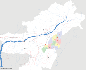
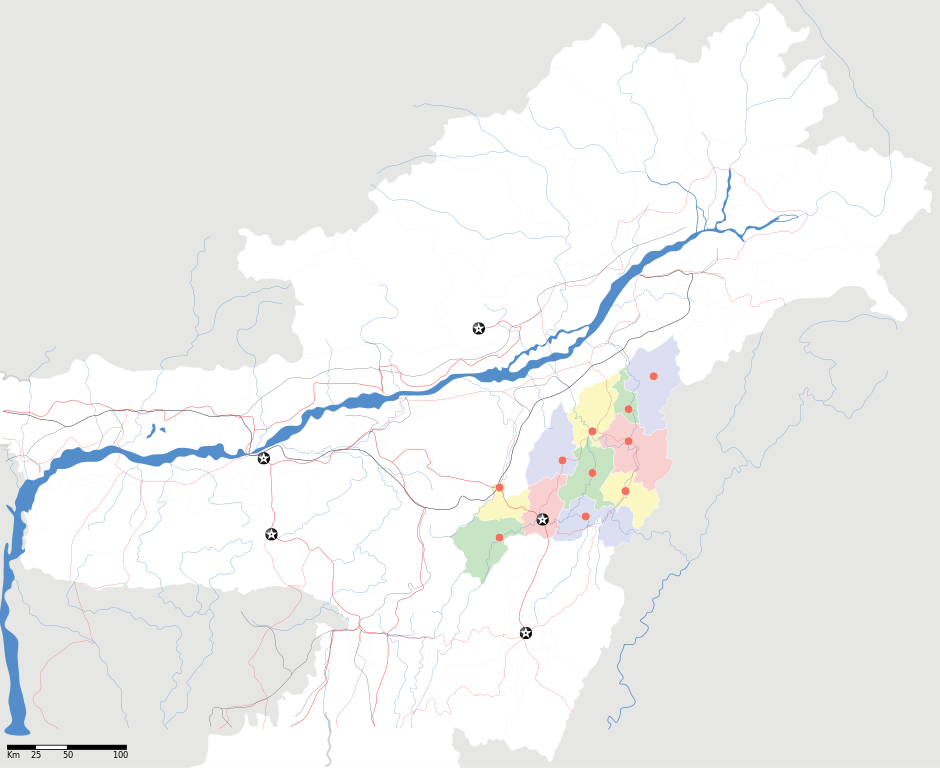
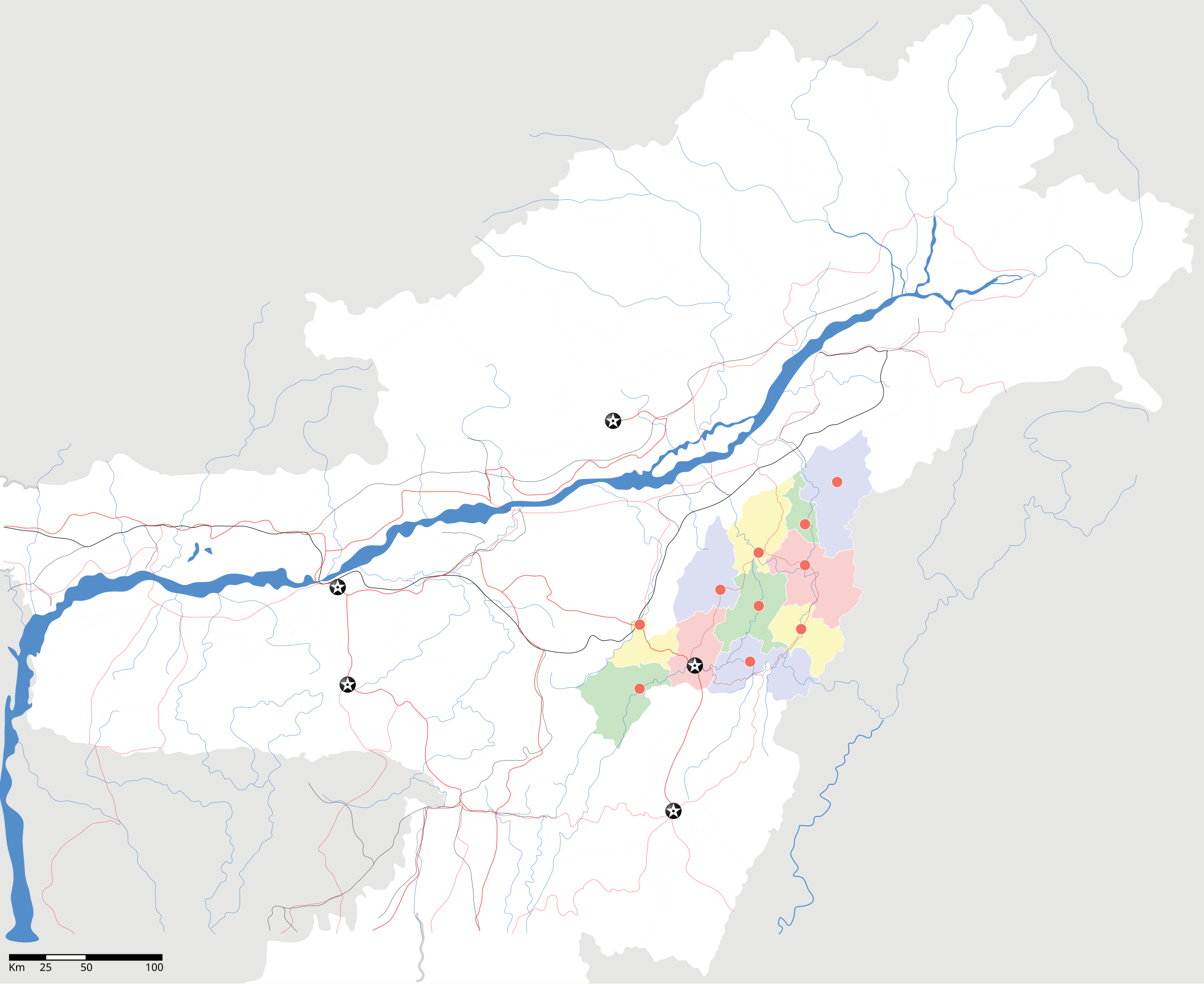
Nagaland locator Map |
| Description |
Map of w:Nagaland with road and rail lines. Equirectangular projection. Geographic limits of the map: top=29.49, bottom=23.74, left=89.61, right=97.52. |
| ᱢᱟᱹᱦᱤᱛ | |
| ᱯᱷᱮᱰᱟᱛ |
ᱤᱧᱟᱜ ᱠᱟᱹᱢᱤ |
| Creator | |
| ᱟᱹᱭᱫᱟᱹᱨᱤ (ᱱᱚᱣᱟ ᱨᱮᱫ ᱫᱚᱲᱦᱟᱛᱮ ᱵᱮᱵᱷᱟᱨ) |
I, the copyright holder of this work, hereby publish it under the following license: ᱱᱚᱶᱟ ᱨᱮᱫ ᱫᱚ ᱥᱟᱫᱷᱟᱨᱚᱱ ᱥᱤᱨᱡᱟᱹᱣᱟᱜ Attribution-Share Alike 3.0 Unported ᱞᱟᱭᱥᱮᱸᱥ ᱛᱟᱹᱨᱤᱨᱮ ᱢᱮᱱᱟᱜ-ᱟ ᱾
|
| Geotemporal data | |
| Date depicted | second half of 20 century ᱟᱨ 21 century |
| Georeferencing | If inappropriate please set warp_status = skip to hide. |
| Archival data | |
| Notes | Part of WikiProject India Maps |
ᱨᱮᱫ ᱨᱮᱭᱟᱜ ᱱᱟᱜᱟᱢ
ᱚᱠᱛᱚ ᱨᱮ ᱞᱤᱱ ᱢᱮ/ᱚᱠᱛᱚ ᱨᱮ ᱨᱮᱫ ᱧᱮᱞ ᱞᱟᱹᱜᱤᱛ ᱞᱤᱱ ᱢᱮ
| ᱢᱟᱹᱦᱤᱛ/ᱚᱠᱛᱚ | ᱴᱤᱯ | ᱡᱚᱠᱷᱟ | ᱵᱮᱵᱷᱟᱨᱤᱭᱟᱹ | ᱠᱟᱛᱷᱟ | |
|---|---|---|---|---|---|
| ᱱᱤᱛᱚᱜ | ᱑᱒:᱐᱕, ᱑᱗ ᱮᱯᱨᱤᱞ ᱒᱐᱐᱗ | | ᱒,᱓᱙᱓ × ᱑,᱙᱕᱖ (᱒᱗᱗ KB) | Planemad | not displaying, reupload |
| ᱑᱒:᱐᱐, ᱑᱗ ᱮᱯᱨᱤᱞ ᱒᱐᱐᱗ |  | ᱒,᱓᱙᱓ × ᱑,᱙᱕᱖ (᱒᱗᱗ KB) | Planemad | not displaying, reupload | |
| ᱑᱑:᱕᱕, ᱑᱗ ᱮᱯᱨᱤᱞ ᱒᱐᱐᱗ |  | ᱒,᱓᱙᱓ × ᱑,᱙᱕᱖ (᱒᱗᱗ KB) | Planemad | {{WikiProject_India_Maps |Title=Nagaland locator Map |Description=Map of w:Nagaland with road and rail lines |Source= [http://www.iitg.ernet.in/rcilts/assam_political.jpg IIT Guwahati - Assam Political map], [http://nagaland.nic.in/planning&coord/p |
ᱯᱷᱟᱭᱤᱞ ᱵᱮᱣᱦᱟᱨ
ᱱᱚᱸᱰᱮ ᱫᱚ ᱟᱨ ᱮᱴᱟᱜ ᱥᱟᱦᱴᱟᱠᱚ ᱵᱟᱱᱩᱜ-ᱟ ᱡᱟᱸᱦᱟᱸ ᱥᱟᱶᱛᱮ ᱱᱤᱭᱟᱹ ᱨᱮᱫ ᱨᱮᱱᱟᱜ ᱡᱚᱱᱚᱲ ᱢᱮᱱᱟᱜ-ᱟ
ᱡᱮᱜᱮᱛ ᱡᱟᱠᱟᱛ ᱨᱮᱫ ᱵᱮᱵᱷᱟᱨᱟᱜ
ᱱᱚᱶᱟ ᱨᱮᱫᱠᱚ ᱵᱮᱵᱷᱟᱨᱟᱠᱟᱫ ᱣᱤᱠᱤᱠᱚ :
- ar.wikipedia.org ᱨᱮ ᱵᱮᱣᱦᱟᱨ
- ast.wikipedia.org ᱨᱮ ᱵᱮᱣᱦᱟᱨ
- as.wikipedia.org ᱨᱮ ᱵᱮᱣᱦᱟᱨ
- ba.wikipedia.org ᱨᱮ ᱵᱮᱣᱦᱟᱨ
- bh.wikipedia.org ᱨᱮ ᱵᱮᱣᱦᱟᱨ
- bn.wikipedia.org ᱨᱮ ᱵᱮᱣᱦᱟᱨ
- ceb.wikipedia.org ᱨᱮ ᱵᱮᱣᱦᱟᱨ
- de.wikipedia.org ᱨᱮ ᱵᱮᱣᱦᱟᱨ
- en.wikipedia.org ᱨᱮ ᱵᱮᱣᱦᱟᱨ
- en.wikinews.org ᱨᱮ ᱵᱮᱣᱦᱟᱨ
- es.wikipedia.org ᱨᱮ ᱵᱮᱣᱦᱟᱨ
- fa.wikipedia.org ᱨᱮ ᱵᱮᱣᱦᱟᱨ
- hi.wikipedia.org ᱨᱮ ᱵᱮᱣᱦᱟᱨ
- ja.wikipedia.org ᱨᱮ ᱵᱮᱣᱦᱟᱨ
- kbd.wikipedia.org ᱨᱮ ᱵᱮᱣᱦᱟᱨ
- ml.wikipedia.org ᱨᱮ ᱵᱮᱣᱦᱟᱨ
- nl.wikipedia.org ᱨᱮ ᱵᱮᱣᱦᱟᱨ
- or.wikipedia.org ᱨᱮ ᱵᱮᱣᱦᱟᱨ
- pam.wikipedia.org ᱨᱮ ᱵᱮᱣᱦᱟᱨ
- pa.wikipedia.org ᱨᱮ ᱵᱮᱣᱦᱟᱨ
- pnb.wikipedia.org ᱨᱮ ᱵᱮᱣᱦᱟᱨ
- sa.wikipedia.org ᱨᱮ ᱵᱮᱣᱦᱟᱨ
- sw.wikipedia.org ᱨᱮ ᱵᱮᱣᱦᱟᱨ
- ta.wikipedia.org ᱨᱮ ᱵᱮᱣᱦᱟᱨ
- tr.wikipedia.org ᱨᱮ ᱵᱮᱣᱦᱟᱨ
- vi.wikipedia.org ᱨᱮ ᱵᱮᱣᱦᱟᱨ
- war.wikipedia.org ᱨᱮ ᱵᱮᱣᱦᱟᱨ
- www.wikidata.org ᱨᱮ ᱵᱮᱣᱦᱟᱨ
- yo.wikipedia.org ᱨᱮ ᱵᱮᱣᱦᱟᱨ
- zh.wikipedia.org ᱨᱮ ᱵᱮᱣᱦᱟᱨ