
ᱨᱮᱫ:Repuk Makalu Barun Valley Nepal.jpg

ᱧᱮᱞᱡᱚᱝ ᱨᱮᱱᱟᱜ ᱟᱠᱟᱨ:᱖᱒᱒ × ᱖᱐᱐ ᱯᱤᱠᱥᱮᱞ ᱮᱴᱟᱜ ᱨᱤᱡᱚᱞᱩᱥᱚᱱᱥ: ᱒᱔᱙ × ᱒᱔᱐ ᱯᱤᱠᱥᱮᱞ | ᱔᱙᱘ × ᱔᱘᱐ ᱯᱤᱠᱥᱮᱞ | ᱗᱙᱗ × ᱗᱖᱘ ᱯᱤᱠᱥᱮᱞ | ᱑,᱐᱖᱒ × ᱑,᱐᱒᱔ ᱯᱤᱠᱥᱮᱞ | ᱑,᱙᱘᱐ × ᱑,᱙᱐᱙ ᱯᱤᱠᱥᱮᱞ
ᱟᱥᱚᱞ ᱨᱮᱫ (᱑,᱙᱘᱐ x ᱑,᱙᱐᱙ pixels, file size: ᱓.᱓᱙ MB, MIME type: image/jpeg)
ᱢᱩᱬᱩᱛ ᱠᱟᱛᱷᱟ
| ᱵᱤᱵᱚᱨᱚᱱᱤ |
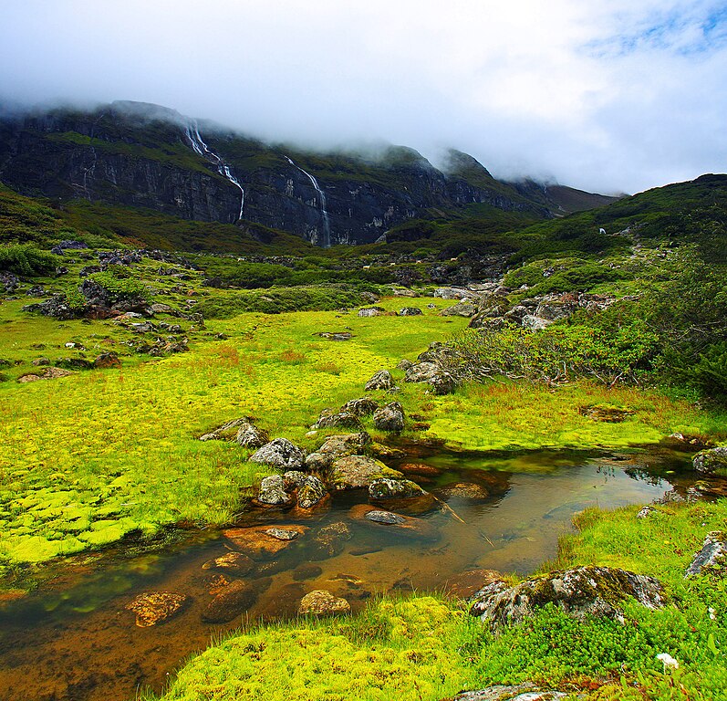
English: This is a place called Ripuk within the Barun Valley. Centuries ago, Barun used to be a glacier here, flowing to the north composing these lush green valleys for today. The cascading waterfalls against the stiff rocks was reflecting the sense of the flowing time and the eternity at the same time. |
| ᱢᱟᱹᱦᱤᱛ | |
| ᱯᱷᱮᱰᱟᱛ | ᱤᱧᱟᱜ ᱠᱟᱹᱢᱤ |
| ᱚᱱᱚᱞᱤᱭᱟᱹ | Dhilung |
| Other versions | https://www.flickr.com/photos/dhilung/3919034860/ |
| Camera location | | View this and other nearby images on: OpenStreetMap |
|---|
ᱞᱟᱭᱥᱮᱱᱥ ᱛᱮᱭᱟᱨ
I, the copyright holder of this work, hereby publish it under the following license:
This file is licensed under the Creative Commons Attribution 3.0 Unported license.
- ᱟᱲᱟᱜ ᱜᱮᱭᱟᱢ:
- ᱦᱟᱹᱴᱤᱧᱢᱮ – ᱱᱚᱠᱚᱞ ᱞᱟᱹᱜᱤᱫ, ᱦᱟᱹᱴᱤᱧ ᱟᱨ ᱵᱷᱮᱡᱟᱭᱢᱮ ᱠᱟᱹᱢᱤ
- ᱢᱮᱥᱟᱣᱠᱟᱛᱢᱮ – ᱠᱟᱹᱢᱤ ᱟᱞᱜᱟᱭ ᱞᱟᱹᱜᱤᱫ
- ᱞᱟᱛᱟᱨ ᱨᱮᱭᱟᱜ ᱨᱤᱛ ᱞᱮᱠᱟᱛᱮ:
- ᱟᱴᱨᱤᱵᱩᱥᱚᱱ – ᱟᱢ ᱠᱟᱹᱢᱤ ᱥᱚᱫᱚᱨ ᱦᱩᱭᱟᱢᱟ ᱡᱚᱠᱷᱚᱱ ᱚᱱᱚᱞᱤᱭᱟᱹ ᱟᱨᱵᱟᱝ ᱞᱟᱭᱥᱮᱸᱥᱩᱭᱟᱹ ᱫᱟᱨᱟᱭᱛᱮ ᱠᱟᱛᱷᱟ ᱨᱟᱠᱟᱵ ᱠᱷᱟᱱ (ᱢᱮᱱᱠᱷᱟᱱ ᱟᱠᱚ ᱩᱫᱩᱜᱟᱜ ᱦᱚᱨ ᱛᱮᱫᱚ ᱵᱟᱝ ᱡᱟᱦᱟᱸ ᱟᱠᱚᱠᱚ ᱜᱚᱲᱚᱣᱟᱢ ᱟᱨᱵᱟᱝ ᱟᱢᱟᱜ ᱠᱟᱹᱢᱤ ᱨᱮᱱᱟᱜ ᱵᱮᱵᱷᱟᱨ)
ᱨᱮᱫ ᱨᱮᱭᱟᱜ ᱱᱟᱜᱟᱢ
ᱚᱠᱛᱚ ᱨᱮ ᱞᱤᱱ ᱢᱮ/ᱚᱠᱛᱚ ᱨᱮ ᱨᱮᱫ ᱧᱮᱞ ᱞᱟᱹᱜᱤᱛ ᱞᱤᱱ ᱢᱮ
| ᱢᱟᱹᱦᱤᱛ/ᱚᱠᱛᱚ | ᱴᱤᱯ | ᱡᱚᱠᱷᱟ | ᱵᱮᱵᱷᱟᱨᱤᱭᱟᱹ | ᱠᱟᱛᱷᱟ | |
|---|---|---|---|---|---|
| ᱱᱤᱛᱚᱜ | ᱒᱒:᱒᱐, ᱑᱖ ᱡᱟᱱᱩᱣᱟᱨᱤ ᱒᱐᱑᱐ | | ᱑,᱙᱘᱐ × ᱑,᱙᱐᱙ (᱓.᱓᱙ MB) | Dhilung | Without watermark removed. GPS info embedded. |
| ᱐᱖:᱓᱑, ᱑᱙ ᱥᱮᱯᱴᱮᱢᱵᱚᱨ ᱒᱐᱐᱙ |  | ᱒,᱑᱕᱐ × ᱒,᱐᱗᱘ (᱒.᱑᱕ MB) | Dhilung | {{Information |Description={{en|1=This is a place called Ripuk within the Barun Valley. Centuries ago, Barun used to be a glacier here, flowing to the north composing these lush green valleys for today. The cascading waterfalls against the stiff rocks was |
ᱯᱷᱟᱭᱤᱞ ᱵᱮᱣᱦᱟᱨ
ᱞᱟᱛᱟᱨ ᱨᱮᱭᱟᱜ 3 ᱥᱟᱦᱴᱟᱠᱚ ᱡᱚᱱᱚᱲ ᱱᱤᱭᱟᱹ ᱨᱮᱫ ᱨᱮ:
ᱡᱮᱜᱮᱛ ᱡᱟᱠᱟᱛ ᱨᱮᱫ ᱵᱮᱵᱷᱟᱨᱟᱜ
ᱱᱚᱶᱟ ᱨᱮᱫᱠᱚ ᱵᱮᱵᱷᱟᱨᱟᱠᱟᱫ ᱣᱤᱠᱤᱠᱚ :
- bh.wikipedia.org ᱨᱮ ᱵᱮᱣᱦᱟᱨ
- bn.wikipedia.org ᱨᱮ ᱵᱮᱣᱦᱟᱨ
- de.wikipedia.org ᱨᱮ ᱵᱮᱣᱦᱟᱨ
- dty.wikipedia.org ᱨᱮ ᱵᱮᱣᱦᱟᱨ
- en.wikipedia.org ᱨᱮ ᱵᱮᱣᱦᱟᱨ
- es.wikipedia.org ᱨᱮ ᱵᱮᱣᱦᱟᱨ
- fa.wikipedia.org ᱨᱮ ᱵᱮᱣᱦᱟᱨ
- fr.wikipedia.org ᱨᱮ ᱵᱮᱣᱦᱟᱨ
- hi.wikipedia.org ᱨᱮ ᱵᱮᱣᱦᱟᱨ
- it.wikipedia.org ᱨᱮ ᱵᱮᱣᱦᱟᱨ
- lt.wikipedia.org ᱨᱮ ᱵᱮᱣᱦᱟᱨ
- mai.wikipedia.org ᱨᱮ ᱵᱮᱣᱦᱟᱨ
- mk.wikipedia.org ᱨᱮ ᱵᱮᱣᱦᱟᱨ
- ml.wikipedia.org ᱨᱮ ᱵᱮᱣᱦᱟᱨ
- ne.wikipedia.org ᱨᱮ ᱵᱮᱣᱦᱟᱨ
- pa.wikipedia.org ᱨᱮ ᱵᱮᱣᱦᱟᱨ
- pnb.wikipedia.org ᱨᱮ ᱵᱮᱣᱦᱟᱨ
- ru.wikipedia.org ᱨᱮ ᱵᱮᱣᱦᱟᱨ
- sa.wikipedia.org ᱨᱮ ᱵᱮᱣᱦᱟᱨ
- sl.wikipedia.org ᱨᱮ ᱵᱮᱣᱦᱟᱨ
- ta.wikipedia.org ᱨᱮ ᱵᱮᱣᱦᱟᱨ
- th.wikipedia.org ᱨᱮ ᱵᱮᱣᱦᱟᱨ
- tt.wikipedia.org ᱨᱮ ᱵᱮᱣᱦᱟᱨ
- ur.wikipedia.org ᱨᱮ ᱵᱮᱣᱦᱟᱨ
- vi.wikipedia.org ᱨᱮ ᱵᱮᱣᱦᱟᱨ
- www.wikidata.org ᱨᱮ ᱵᱮᱣᱦᱟᱨ