
ᱨᱮᱫ:Andorra location map.svg

Size of this PNG preview of this SVG file: ᱖᱘᱓ × ᱕᱙᱙ ᱯᱤᱠᱥᱮᱞ. ᱮᱴᱟᱜ ᱨᱤᱡᱚᱞᱩᱥᱚᱱᱥ: ᱒᱗᱔ × ᱒᱔᱐ ᱯᱤᱠᱥᱮᱞ | ᱕᱔᱗ × ᱔᱘᱐ ᱯᱤᱠᱥᱮᱞ | ᱘᱗᱕ × ᱗᱖᱘ ᱯᱤᱠᱥᱮᱞ | ᱑,᱑᱖᱗ × ᱑,᱐᱒᱔ ᱯᱤᱠᱥᱮᱞ | ᱒,᱓᱓᱓ × ᱒,᱐᱔᱘ ᱯᱤᱠᱥᱮᱞ | ᱑,᱑᱖᱑ × ᱑,᱐᱑᱙ ᱯᱤᱠᱥᱮᱞ
ᱟᱥᱚᱞ ᱨᱮᱫ (SVG ᱨᱮᱫ, ᱱᱚᱨᱢᱟᱞᱛᱮ ᱑,᱑᱖᱑ x ᱑,᱐᱑᱙ pixels, ᱨᱮᱫ ᱡᱟᱜᱟ: ᱑᱔᱙ KB)
ᱢᱩᱬᱩᱛ ᱠᱟᱛᱷᱟ
| ᱵᱤᱵᱚᱨᱚᱱᱤ |
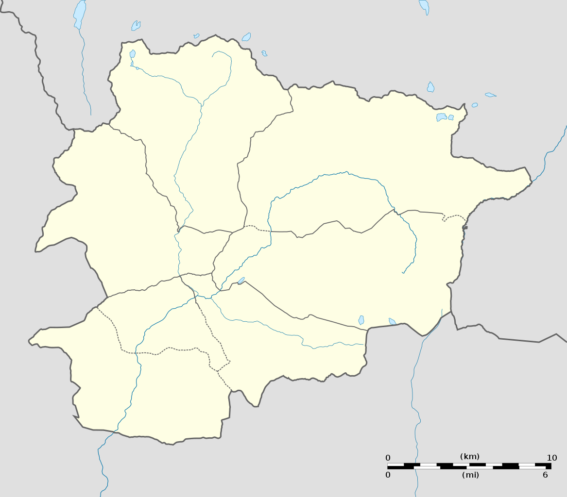
English: Blank administrative map of Andorra with parishes boundaries for geo-location purpose.
Note: Dotted lines are boundaries estimated from very small scale reference maps. Français : Carte administrative vierge de l'Andorre avec limites des paroisses destinée à la géolocalisation. Note : les lignes pointillées sont des limites estimées à partir de cartes de référence à très petite échelle. Equirectangular projection, WGS84 datum
Topographic scale: 1:372,000 (precision: 93 m)
|
||
| ᱢᱟᱹᱦᱤᱛ | |||
| ᱯᱷᱮᱰᱟᱛ |
ᱤᱧᱟᱜ ᱠᱟᱹᱢᱤ (Original text: Own work) |
||
| ᱚᱱᱚᱞᱤᱭᱟᱹ | Eric Gaba (Sting - fr:Sting) | ||
| ᱟᱹᱭᱫᱟᱹᱨᱤ (ᱱᱚᱣᱟ ᱨᱮᱫ ᱫᱚᱲᱦᱟᱛᱮ ᱵᱮᱵᱷᱟᱨ) |
|
||
| Other versions |
|
||
| SVG genesis |

| Camera location | | View this and other nearby images on: OpenStreetMap |
|---|
ᱞᱟᱭᱥᱮᱱᱥ ᱛᱮᱭᱟᱨ
I, the copyright holder of this work, hereby publish it under the following licenses:
ᱱᱚᱶᱟ ᱨᱮᱫ ᱫᱚ ᱥᱟᱫᱷᱟᱨᱚᱱ ᱥᱤᱨᱡᱟᱹᱣᱟᱜ Attribution-Share Alike 3.0 Unported ᱞᱟᱭᱥᱮᱸᱥ ᱛᱟᱹᱨᱤᱨᱮ ᱢᱮᱱᱟᱜ-ᱟ ᱾
- ᱟᱲᱟᱜ ᱜᱮᱭᱟᱢ:
- ᱦᱟᱹᱴᱤᱧᱢᱮ – ᱱᱚᱠᱚᱞ ᱞᱟᱹᱜᱤᱫ, ᱦᱟᱹᱴᱤᱧ ᱟᱨ ᱵᱷᱮᱡᱟᱭᱢᱮ ᱠᱟᱹᱢᱤ
- ᱢᱮᱥᱟᱣᱠᱟᱛᱢᱮ – ᱠᱟᱹᱢᱤ ᱟᱞᱜᱟᱭ ᱞᱟᱹᱜᱤᱫ
- ᱞᱟᱛᱟᱨ ᱨᱮᱭᱟᱜ ᱨᱤᱛ ᱞᱮᱠᱟᱛᱮ:
- ᱟᱴᱨᱤᱵᱩᱥᱚᱱ – ᱟᱢ ᱠᱟᱹᱢᱤ ᱥᱚᱫᱚᱨ ᱦᱩᱭᱟᱢᱟ ᱡᱚᱠᱷᱚᱱ ᱚᱱᱚᱞᱤᱭᱟᱹ ᱟᱨᱵᱟᱝ ᱞᱟᱭᱥᱮᱸᱥᱩᱭᱟᱹ ᱫᱟᱨᱟᱭᱛᱮ ᱠᱟᱛᱷᱟ ᱨᱟᱠᱟᱵ ᱠᱷᱟᱱ (ᱢᱮᱱᱠᱷᱟᱱ ᱟᱠᱚ ᱩᱫᱩᱜᱟᱜ ᱦᱚᱨ ᱛᱮᱫᱚ ᱵᱟᱝ ᱡᱟᱦᱟᱸ ᱟᱠᱚᱠᱚ ᱜᱚᱲᱚᱣᱟᱢ ᱟᱨᱵᱟᱝ ᱟᱢᱟᱜ ᱠᱟᱹᱢᱤ ᱨᱮᱱᱟᱜ ᱵᱮᱵᱷᱟᱨ)
- ᱦᱟᱹᱴᱤᱧ ᱱᱚᱝᱠᱟ ᱜᱮ – ᱟᱢ ᱡᱩᱫᱤ ᱠᱟᱹᱢᱤ ᱵᱚᱫᱚᱞ, ᱛᱚᱨᱡᱚᱢᱟ, ᱵᱟᱝᱠᱷᱟᱱ ᱱᱚᱣᱟ ᱠᱟᱹᱢᱤ ᱪᱮᱛᱟᱱᱨᱮ ᱱᱟᱣᱟ ᱠᱟᱹᱢᱤ ᱥᱤᱨᱡᱟᱹᱣᱮᱢ ᱛᱮᱭᱟᱨ ᱠᱷᱟᱱ, ᱛᱚᱵᱮ ᱟᱢ ᱫᱚ ᱚᱱᱟ ᱠᱟᱹᱢᱤ ᱚᱱᱟ ᱢᱤᱫ ᱞᱟᱤᱥᱮᱱᱥ ᱥᱮ ᱚᱱᱟ ᱞᱮᱠᱟᱱᱟᱜ ᱞᱟᱤᱥᱮᱱᱥ ᱨᱮᱜᱮ ᱪᱟᱞ ᱦᱩᱭᱩᱜ ᱛᱟᱢᱟ᱾

|
ᱫᱟᱣ ᱮᱢᱮᱱᱟ ᱱᱚᱠᱚᱞ, ᱦᱟᱹᱴᱤᱧ ᱟᱨ/ᱟᱨᱵᱟᱝ ᱟᱹᱨᱩᱯᱷᱮᱨᱟᱣ ᱞᱟᱹᱜᱤᱫ ᱱᱚᱶᱟ ᱱᱩᱛᱷᱤ ᱠᱚ GNU Free Documentation License ᱟᱹᱨᱤ ᱛᱮ, ᱵᱷᱟᱨᱥᱚᱱ ᱑.᱒ ᱟᱨᱵᱟᱝ ᱡᱟᱦᱟᱸᱜᱮ ᱛᱟᱭᱚᱢᱟᱜ ᱵᱷᱟᱨᱥᱚᱱ Free Software Foundation ᱫᱟᱨᱟᱭᱛᱮ ᱩᱪᱷᱟᱹᱱ ᱟᱠᱟᱱ; ᱵᱤᱱ ᱵᱷᱮᱯᱮᱜᱮᱫ ᱦᱟᱹᱴᱤᱧ, ᱵᱤᱱ ᱥᱟᱢᱟᱝ ᱚᱞᱠᱚ, ᱟᱨ ᱵᱤᱱ ᱯᱟᱹᱪᱷᱞᱟᱹ ᱚᱞᱠᱚ ᱥᱟᱶᱛᱮ ᱾ ᱢᱤᱫ GNU Free Documentation License ᱧᱩᱛᱩᱢᱟᱱ ᱞᱟᱭᱥᱮᱸᱥ ᱨᱮᱱᱟᱜ ᱱᱚᱠᱚᱞ ᱡᱚᱲᱟᱣᱮᱱᱟ ᱾ |
ᱟᱢᱟᱜ ᱠᱩᱥᱤ ᱞᱮᱠᱟᱛᱮ ᱞᱟᱭᱥᱮᱱᱥ ᱵᱟᱪᱷᱟᱣ ᱫᱟᱲᱮᱭᱟᱜ ᱟᱢ᱾
ᱨᱮᱫ ᱨᱮᱭᱟᱜ ᱱᱟᱜᱟᱢ
ᱚᱠᱛᱚ ᱨᱮ ᱞᱤᱱ ᱢᱮ/ᱚᱠᱛᱚ ᱨᱮ ᱨᱮᱫ ᱧᱮᱞ ᱞᱟᱹᱜᱤᱛ ᱞᱤᱱ ᱢᱮ
| ᱢᱟᱹᱦᱤᱛ/ᱚᱠᱛᱚ | ᱴᱤᱯ | ᱡᱚᱠᱷᱟ | ᱵᱮᱵᱷᱟᱨᱤᱭᱟᱹ | ᱠᱟᱛᱷᱟ | |
|---|---|---|---|---|---|
| ᱱᱤᱛᱚᱜ | ᱒᱐:᱐᱖, ᱒᱗ ᱰᱤᱥᱮᱢᱵᱚᱨ ᱒᱐᱑᱐ | | ᱑,᱑᱖᱑ × ᱑,᱐᱑᱙ (᱑᱔᱙ KB) | Sting | Added parishes boundaries (some of them estimated) |
| ᱒᱐:᱐᱒, ᱑᱗ ᱰᱤᱥᱮᱢᱵᱚᱨ ᱒᱐᱐᱘ |  | ᱑,᱑᱖᱑ × ᱑,᱐᱑᱙ (᱑᱔᱒ KB) | Sting | Deleted temporary parishes boundaries | |
| ᱒᱐:᱐᱑, ᱑᱗ ᱰᱤᱥᱮᱢᱵᱚᱨ ᱒᱐᱐᱘ |  | ᱑,᱑᱖᱑ × ᱑,᱐᱑᱙ (᱑᱗᱑ KB) | Sting | Corrections on international boundaries; added (incomplete but reliable) parishes boundaries | |
| ᱒᱐:᱒᱔, ᱑᱖ ᱰᱤᱥᱮᱢᱵᱚᱨ ᱒᱐᱐᱘ |  | ᱑,᱑᱖᱑ × ᱑,᱐᱑᱙ (᱑᱑᱖ KB) | Sting | == Summary == {{Location|42|32|15|N|01|36|00|E|scale:200000}} <br/> {{Information |Description={{en|Blank administrative map of Andorra for geo-location purpose.}} {{fr|Carte administrative vierge de l'Andorre destinée à |
ᱯᱷᱟᱭᱤᱞ ᱵᱮᱣᱦᱟᱨ
ᱞᱟᱛᱟᱨ ᱨᱮᱭᱟᱜ 2 ᱥᱟᱦᱴᱟᱠᱚ ᱡᱚᱱᱚᱲ ᱱᱤᱭᱟᱹ ᱨᱮᱫ ᱨᱮ:
ᱡᱮᱜᱮᱛ ᱡᱟᱠᱟᱛ ᱨᱮᱫ ᱵᱮᱵᱷᱟᱨᱟᱜ
ᱱᱚᱶᱟ ᱨᱮᱫᱠᱚ ᱵᱮᱵᱷᱟᱨᱟᱠᱟᱫ ᱣᱤᱠᱤᱠᱚ :
- af.wikipedia.org ᱨᱮ ᱵᱮᱣᱦᱟᱨ
- an.wikipedia.org ᱨᱮ ᱵᱮᱣᱦᱟᱨ
- ar.wikipedia.org ᱨᱮ ᱵᱮᱣᱦᱟᱨ
- ast.wikipedia.org ᱨᱮ ᱵᱮᱣᱦᱟᱨ
- Les Escaldes
- Puertu d'Envalira
- Andorra la Vieya
- Soldeu
- Llagos de Tristaina
- El Tarter
- Incles
- Arans
- Comapedrosa
- Módulu:Mapa de llocalización/datos/Andorra
- Módulu:Mapa de llocalización/datos/Andorra/usu
- Helipuertu d'Andorra la Vieya
- Casa de la Vall
- Ilesia de San Esteban (Andorra)
- Pont de la Margineda
- Ilesia de Sant Vicenç d'Enclar
- Ilesia de Santa Coloma (Andorra)
- Hospital Nostra Senyora de Meritxell
- av.wikipedia.org ᱨᱮ ᱵᱮᱣᱦᱟᱨ
- az.wikipedia.org ᱨᱮ ᱵᱮᱣᱦᱟᱨ
- ba.wikipedia.org ᱨᱮ ᱵᱮᱣᱦᱟᱨ
- be-tarask.wikipedia.org ᱨᱮ ᱵᱮᱣᱦᱟᱨ
- be.wikipedia.org ᱨᱮ ᱵᱮᱣᱦᱟᱨ
- bg.wikipedia.org ᱨᱮ ᱵᱮᱣᱦᱟᱨ
- bn.wikipedia.org ᱨᱮ ᱵᱮᱣᱦᱟᱨ
- bs.wikipedia.org ᱨᱮ ᱵᱮᱣᱦᱟᱨ
ᱱᱚᱶᱟ ᱨᱮᱫ ᱨᱮᱱᱟᱜ ᱵᱟᱹᱲᱛᱤ ᱡᱮᱜᱮᱛ ᱵᱮᱵᱷᱟᱨ ᱧᱮᱞ ᱢᱮ ᱾