
ᱨᱮᱫ:Barun Valley - Nghe.jpg

ᱧᱮᱞᱡᱚᱝ ᱨᱮᱱᱟᱜ ᱟᱠᱟᱨ:᱖᱓᱑ × ᱖᱐᱐ ᱯᱤᱠᱥᱮᱞ ᱮᱴᱟᱜ ᱨᱤᱡᱚᱞᱩᱥᱚᱱᱥ: ᱒᱕᱓ × ᱒᱔᱐ ᱯᱤᱠᱥᱮᱞ | ᱕᱐᱕ × ᱔᱘᱐ ᱯᱤᱠᱥᱮᱞ | ᱘᱐᱘ × ᱗᱖᱘ ᱯᱤᱠᱥᱮᱞ | ᱑,᱐᱗᱗ × ᱑,᱐᱒᱔ ᱯᱤᱠᱥᱮᱞ | ᱑,᱙᱘᱐ × ᱑,᱘᱘᱒ ᱯᱤᱠᱥᱮᱞ
ᱟᱥᱚᱞ ᱨᱮᱫ (᱑,᱙᱘᱐ x ᱑,᱘᱘᱒ pixels, file size: ᱒.᱐᱑ MB, MIME type: image/jpeg)
ᱢᱩᱬᱩᱛ ᱠᱟᱛᱷᱟ
| ᱵᱤᱵᱚᱨᱚᱱᱤ |
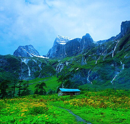
English: Place called Nghe along the Barun Valley. Nghe in local Sherpa language means a 'Sacred Place'. |
| ᱢᱟᱹᱦᱤᱛ | |
| ᱯᱷᱮᱰᱟᱛ | ᱤᱧᱟᱜ ᱠᱟᱹᱢᱤ |
| ᱚᱱᱚᱞᱤᱭᱟᱹ | Dhilung |
| Other versions | https://www.flickr.com/photos/dhilung/3904555723/ |
| Camera location | | View this and other nearby images on: OpenStreetMap |
|---|
ᱞᱟᱭᱥᱮᱱᱥ ᱛᱮᱭᱟᱨ
I, the copyright holder of this work, hereby publish it under the following license:
This file is licensed under the Creative Commons Attribution 3.0 Unported license.
- ᱟᱲᱟᱜ ᱜᱮᱭᱟᱢ:
- ᱦᱟᱹᱴᱤᱧᱢᱮ – ᱱᱚᱠᱚᱞ ᱞᱟᱹᱜᱤᱫ, ᱦᱟᱹᱴᱤᱧ ᱟᱨ ᱵᱷᱮᱡᱟᱭᱢᱮ ᱠᱟᱹᱢᱤ
- ᱢᱮᱥᱟᱣᱠᱟᱛᱢᱮ – ᱠᱟᱹᱢᱤ ᱟᱞᱜᱟᱭ ᱞᱟᱹᱜᱤᱫ
- ᱞᱟᱛᱟᱨ ᱨᱮᱭᱟᱜ ᱨᱤᱛ ᱞᱮᱠᱟᱛᱮ:
- ᱟᱴᱨᱤᱵᱩᱥᱚᱱ – ᱟᱢ ᱠᱟᱹᱢᱤ ᱥᱚᱫᱚᱨ ᱦᱩᱭᱟᱢᱟ ᱡᱚᱠᱷᱚᱱ ᱚᱱᱚᱞᱤᱭᱟᱹ ᱟᱨᱵᱟᱝ ᱞᱟᱭᱥᱮᱸᱥᱩᱭᱟᱹ ᱫᱟᱨᱟᱭᱛᱮ ᱠᱟᱛᱷᱟ ᱨᱟᱠᱟᱵ ᱠᱷᱟᱱ (ᱢᱮᱱᱠᱷᱟᱱ ᱟᱠᱚ ᱩᱫᱩᱜᱟᱜ ᱦᱚᱨ ᱛᱮᱫᱚ ᱵᱟᱝ ᱡᱟᱦᱟᱸ ᱟᱠᱚᱠᱚ ᱜᱚᱲᱚᱣᱟᱢ ᱟᱨᱵᱟᱝ ᱟᱢᱟᱜ ᱠᱟᱹᱢᱤ ᱨᱮᱱᱟᱜ ᱵᱮᱵᱷᱟᱨ)
ᱨᱮᱫ ᱨᱮᱭᱟᱜ ᱱᱟᱜᱟᱢ
ᱚᱠᱛᱚ ᱨᱮ ᱞᱤᱱ ᱢᱮ/ᱚᱠᱛᱚ ᱨᱮ ᱨᱮᱫ ᱧᱮᱞ ᱞᱟᱹᱜᱤᱛ ᱞᱤᱱ ᱢᱮ
| ᱢᱟᱹᱦᱤᱛ/ᱚᱠᱛᱚ | ᱴᱤᱯ | ᱡᱚᱠᱷᱟ | ᱵᱮᱵᱷᱟᱨᱤᱭᱟᱹ | ᱠᱟᱛᱷᱟ | |
|---|---|---|---|---|---|
| ᱱᱤᱛᱚᱜ | ᱐᱖:᱐᱖, ᱒᱙ ᱡᱩᱞᱟᱭ ᱒᱐᱑᱘ | | ᱑,᱙᱘᱐ × ᱑,᱘᱘᱒ (᱒.᱐᱑ MB) | WikiPedant | Reverted to version as of 18:56, 14 December 2009 (UTC). My previous version had splotchiness in the clouds. I may try again to correct saturation, later. |
| ᱐᱕:᱕᱑, ᱒᱙ ᱡᱩᱞᱟᱭ ᱒᱐᱑᱘ |  | ᱑,᱙᱘᱐ × ᱑,᱘᱘᱒ (᱒.᱐᱓ MB) | WikiPedant | Corrected extreme oversaturation. (A great shot!) | |
| ᱑᱘:᱕᱖, ᱑᱔ ᱰᱤᱥᱮᱢᱵᱚᱨ ᱒᱐᱐᱙ |  | ᱑,᱙᱘᱐ × ᱑,᱘᱘᱒ (᱒.᱐᱑ MB) | Dhilung | Larger resolution file without watermark. | |
| ᱒᱑:᱑᱐, ᱙ ᱥᱮᱯᱴᱮᱢᱵᱚᱨ ᱒᱐᱐᱙ |  | ᱑,᱑᱒᱕ × ᱑,᱐᱐᱑ (᱗᱐᱖ KB) | Dhilung | {{Information |Description={{en|1=Place called Nghe along the Barun Valley. Nghe in local Sherpa language means a 'Sacred Place'.}} |Source=Own work by uploader |Author=Dhilung |Date=2009-08-15 |Permission= |other_versions= }} {{location |
ᱯᱷᱟᱭᱤᱞ ᱵᱮᱣᱦᱟᱨ
ᱞᱟᱛᱟᱨ ᱨᱮᱭᱟᱜ ᱥᱟᱦᱴᱟ ᱡᱚᱱᱚᱲᱠᱚ ᱱᱤᱭᱟᱹ ᱨᱮᱫ ᱨᱮ:
ᱡᱮᱜᱮᱛ ᱡᱟᱠᱟᱛ ᱨᱮᱫ ᱵᱮᱵᱷᱟᱨᱟᱜ
ᱱᱚᱶᱟ ᱨᱮᱫᱠᱚ ᱵᱮᱵᱷᱟᱨᱟᱠᱟᱫ ᱣᱤᱠᱤᱠᱚ :
- ast.wikipedia.org ᱨᱮ ᱵᱮᱣᱦᱟᱨ
- az.wikipedia.org ᱨᱮ ᱵᱮᱣᱦᱟᱨ
- ban.wikipedia.org ᱨᱮ ᱵᱮᱣᱦᱟᱨ
- bh.wikipedia.org ᱨᱮ ᱵᱮᱣᱦᱟᱨ
- bn.wikipedia.org ᱨᱮ ᱵᱮᱣᱦᱟᱨ
- cs.wikipedia.org ᱨᱮ ᱵᱮᱣᱦᱟᱨ
- da.wikipedia.org ᱨᱮ ᱵᱮᱣᱦᱟᱨ
- de.wikipedia.org ᱨᱮ ᱵᱮᱣᱦᱟᱨ
- dty.wikipedia.org ᱨᱮ ᱵᱮᱣᱦᱟᱨ
- en.wikipedia.org ᱨᱮ ᱵᱮᱣᱦᱟᱨ
- es.wikipedia.org ᱨᱮ ᱵᱮᱣᱦᱟᱨ
- hi.wikipedia.org ᱨᱮ ᱵᱮᱣᱦᱟᱨ
- hu.wikipedia.org ᱨᱮ ᱵᱮᱣᱦᱟᱨ
- hyw.wikipedia.org ᱨᱮ ᱵᱮᱣᱦᱟᱨ
- it.wikipedia.org ᱨᱮ ᱵᱮᱣᱦᱟᱨ
- lt.wikipedia.org ᱨᱮ ᱵᱮᱣᱦᱟᱨ
- mai.wikipedia.org ᱨᱮ ᱵᱮᱣᱦᱟᱨ
- mk.wikipedia.org ᱨᱮ ᱵᱮᱣᱦᱟᱨ
- ml.wikipedia.org ᱨᱮ ᱵᱮᱣᱦᱟᱨ
- ne.wikipedia.org ᱨᱮ ᱵᱮᱣᱦᱟᱨ
- संरक्षित क्षेत्र
- बरुण उपत्यका
- मकालु-बरूण राष्ट्रिय निकुञ्ज
- ढाँचा:प्रमुख चित्र/२०१४-०३-२०
- ढाँचा:प्रमुख चित्र/मार्च २०१४
- विकिपीडिया:प्रमुख चित्र/मार्च २०१४
- विकिपीडिया:प्रमुख चित्र/जुलाई २०१५
- ढाँचा:प्रमुख चित्र/जुलाई २०१५
- ढाँचा:प्रमुख चित्र/२०१५-०७-०१
- विकिपीडिया:प्रमुख चित्र/अक्टोबर २०१६
- ढाँचा:प्रमुख चित्र/अक्टोबर २०१६
- ढाँचा:प्रमुख चित्र/२०१६-१०-२०
ᱱᱚᱶᱟ ᱨᱮᱫ ᱨᱮᱱᱟᱜ ᱵᱟᱹᱲᱛᱤ ᱡᱮᱜᱮᱛ ᱵᱮᱵᱷᱟᱨ ᱧᱮᱞ ᱢᱮ ᱾