
ᱨᱮᱫ:Bhutan-distretti-numerato.png
ᱥᱮᱬᱟ ᱨᱮᱡᱩᱞᱮᱥᱚᱱ ᱵᱟᱱᱩᱜ-ᱟ᱾
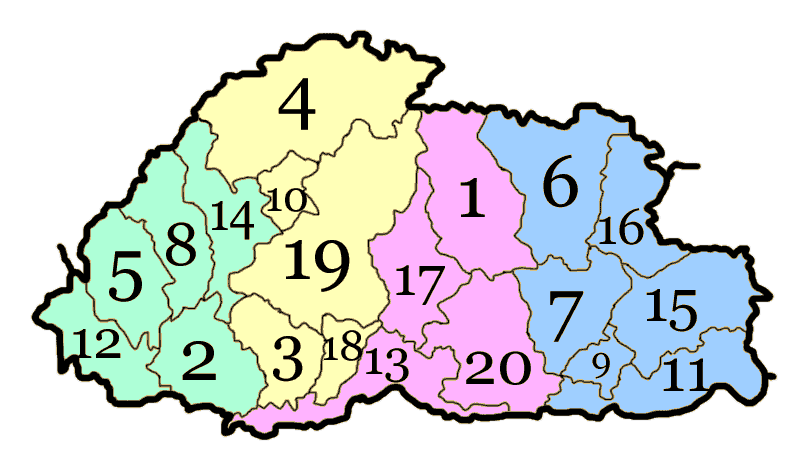
Bhutan-distretti-numerato.png (᱘᱐᱐ x ᱔᱔᱙ pixels, file size: ᱕᱐ KB, MIME type: image/png)
ᱢᱩᱬᱩᱛ ᱠᱟᱛᱷᱟ
| ᱵᱤᱵᱚᱨᱚᱱᱤ | Divisione amministrativa del Bhutan con colorazione degli Dzongdey |
| ᱢᱟᱹᱦᱤᱛ | |
| ᱯᱷᱮᱰᱟᱛ | self-made;versione precedente (Made by Nichalp 18:52, August 8, 2005 (UTC) + Modifica di Reddy (inserimento numerazione |
| ᱚᱱᱚᱞᱤᱭᱟᱹ | Ysogo |
| ᱟᱹᱭᱫᱟᱹᱨᱤ (ᱱᱚᱣᱟ ᱨᱮᱫ ᱫᱚᱲᱦᱟᱛᱮ ᱵᱮᱵᱷᱟᱨ) |
Creative Commons |
| Other versions | Derivative works of this file: Zones of Bhutan.svg |
ᱞᱟᱭᱥᱮᱱᱥ ᱛᱮᱭᱟᱨ
| I, the copyright holder of this work, release this work into the public domain. This applies worldwide. In some countries this may not be legally possible; if so: I grant anyone the right to use this work for any purpose, without any conditions, unless such conditions are required by law. |

|
This locator map image could be re-created using vector graphics as an SVG file. This has several advantages; see Commons:Media for cleanup for more information. If an SVG form of this image is available, please upload it and afterwards replace this template with
{{vector version available|new image name}}.
It is recommended to name the SVG file “Bhutan-distretti-numerato.svg”—then the template Vector version available (or Vva) does not need the new image name parameter. |
ᱨᱮᱫ ᱨᱮᱭᱟᱜ ᱱᱟᱜᱟᱢ
ᱚᱠᱛᱚ ᱨᱮ ᱞᱤᱱ ᱢᱮ/ᱚᱠᱛᱚ ᱨᱮ ᱨᱮᱫ ᱧᱮᱞ ᱞᱟᱹᱜᱤᱛ ᱞᱤᱱ ᱢᱮ
| ᱢᱟᱹᱦᱤᱛ/ᱚᱠᱛᱚ | ᱴᱤᱯ | ᱡᱚᱠᱷᱟ | ᱵᱮᱵᱷᱟᱨᱤᱭᱟᱹ | ᱠᱟᱛᱷᱟ | |
|---|---|---|---|---|---|
| ᱱᱤᱛᱚᱜ | ᱐᱘:᱕᱒, ᱘ ᱯᱷᱮᱵᱽᱨᱩᱣᱟᱨᱤ ᱒᱐᱑᱐ | | ᱘᱐᱐ × ᱔᱔᱙ (᱕᱐ KB) | PhiLiP | new edition |
| ᱑᱘:᱓᱘, ᱙ ᱰᱤᱥᱮᱢᱵᱚᱨ ᱒᱐᱐᱗ |  | ᱘᱐᱐ × ᱔᱔᱙ (᱓᱖ KB) | Ysogo | {{Information |Description=Divisione amministrativa del Bhutan con colorazione degli Dzongdey |Source=self-made;versione precedente (Made by Nichalp 18:52, August 8, 2005 (UTC) + Modifica di Reddy (inserimento numerazione |Date=06.Nov.2007 |Author= [[User |
ᱯᱷᱟᱭᱤᱞ ᱵᱮᱣᱦᱟᱨ
ᱱᱚᱸᱰᱮ ᱫᱚ ᱟᱨ ᱮᱴᱟᱜ ᱥᱟᱦᱴᱟᱠᱚ ᱵᱟᱱᱩᱜ-ᱟ ᱡᱟᱸᱦᱟᱸ ᱥᱟᱶᱛᱮ ᱱᱤᱭᱟᱹ ᱨᱮᱫ ᱨᱮᱱᱟᱜ ᱡᱚᱱᱚᱲ ᱢᱮᱱᱟᱜ-ᱟ
ᱡᱮᱜᱮᱛ ᱡᱟᱠᱟᱛ ᱨᱮᱫ ᱵᱮᱵᱷᱟᱨᱟᱜ
ᱱᱚᱶᱟ ᱨᱮᱫᱠᱚ ᱵᱮᱵᱷᱟᱨᱟᱠᱟᱫ ᱣᱤᱠᱤᱠᱚ :
- az.wikipedia.org ᱨᱮ ᱵᱮᱣᱦᱟᱨ
- bg.wikipedia.org ᱨᱮ ᱵᱮᱣᱦᱟᱨ
- ca.wikipedia.org ᱨᱮ ᱵᱮᱣᱦᱟᱨ
- de.wikipedia.org ᱨᱮ ᱵᱮᱣᱦᱟᱨ
- en.wikipedia.org ᱨᱮ ᱵᱮᱣᱦᱟᱨ
- eo.wikipedia.org ᱨᱮ ᱵᱮᱣᱦᱟᱨ
- es.wikipedia.org ᱨᱮ ᱵᱮᱣᱦᱟᱨ
- fr.wikipedia.org ᱨᱮ ᱵᱮᱣᱦᱟᱨ
- hu.wikipedia.org ᱨᱮ ᱵᱮᱣᱦᱟᱨ
- it.wikipedia.org ᱨᱮ ᱵᱮᱣᱦᱟᱨ
- ka.wikipedia.org ᱨᱮ ᱵᱮᱣᱦᱟᱨ
- kv.wikipedia.org ᱨᱮ ᱵᱮᱣᱦᱟᱨ
- la.wikipedia.org ᱨᱮ ᱵᱮᱣᱦᱟᱨ
- lez.wikipedia.org ᱨᱮ ᱵᱮᱣᱦᱟᱨ
- lt.wikipedia.org ᱨᱮ ᱵᱮᱣᱦᱟᱨ
- mt.wikipedia.org ᱨᱮ ᱵᱮᱣᱦᱟᱨ
- myv.wikipedia.org ᱨᱮ ᱵᱮᱣᱦᱟᱨ
- pt.wikipedia.org ᱨᱮ ᱵᱮᱣᱦᱟᱨ
- ru.wikipedia.org ᱨᱮ ᱵᱮᱣᱦᱟᱨ
- sr.wikipedia.org ᱨᱮ ᱵᱮᱣᱦᱟᱨ
- sv.wikipedia.org ᱨᱮ ᱵᱮᱣᱦᱟᱨ
- uk.wikipedia.org ᱨᱮ ᱵᱮᱣᱦᱟᱨ
- vi.wikipedia.org ᱨᱮ ᱵᱮᱣᱦᱟᱨ
- xmf.wikipedia.org ᱨᱮ ᱵᱮᱣᱦᱟᱨ
- zh.wikipedia.org ᱨᱮ ᱵᱮᱣᱦᱟᱨ