
ᱨᱮᱫ:Majuro Satellite.PNG

ᱧᱮᱞᱡᱚᱝ ᱨᱮᱱᱟᱜ ᱟᱠᱟᱨ:᱘᱐᱐ × ᱔᱑᱖ ᱯᱤᱠᱥᱮᱞ ᱮᱴᱟᱜ ᱨᱤᱡᱚᱞᱩᱥᱚᱱᱥ: ᱓᱒᱐ × ᱑᱖᱗ ᱯᱤᱠᱥᱮᱞ | ᱖᱔᱐ × ᱓᱓᱓ ᱯᱤᱠᱥᱮᱞ | ᱑,᱐᱒᱔ × ᱕᱓᱓ ᱯᱤᱠᱥᱮᱞ | ᱑,᱙᱑᱘ × ᱙᱙᱘ ᱯᱤᱠᱥᱮᱞ
ᱟᱥᱚᱞ ᱨᱮᱫ (᱑,᱙᱑᱘ x ᱙᱙᱘ pixels, file size: ᱕.᱔᱙ MB, MIME type: image/png)
ᱢᱩᱬᱩᱛ ᱠᱟᱛᱷᱟ
| ᱵᱤᱵᱚᱨᱚᱱᱤ |
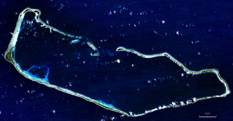
English: visible color satellite image of Majuro Atoll, Marshall Islands, Pacific Ocean |
| ᱢᱟᱹᱦᱤᱛ | |
| ᱯᱷᱮᱰᱟᱛ | NASA World Wind Screenshot (visible color) |
| ᱚᱱᱚᱞᱤᱭᱟᱹ | NASA |
ᱞᱟᱭᱥᱮᱱᱥ ᱛᱮᱭᱟᱨ
| This image is in the public domain because it is a screenshot from NASA’s globe software World Wind using a public domain layer, such as Blue Marble, MODIS, Landsat, SRTM, USGS or GLOBE.
|
 |
ᱨᱮᱫ ᱨᱮᱭᱟᱜ ᱱᱟᱜᱟᱢ
ᱚᱠᱛᱚ ᱨᱮ ᱞᱤᱱ ᱢᱮ/ᱚᱠᱛᱚ ᱨᱮ ᱨᱮᱫ ᱧᱮᱞ ᱞᱟᱹᱜᱤᱛ ᱞᱤᱱ ᱢᱮ
| ᱢᱟᱹᱦᱤᱛ/ᱚᱠᱛᱚ | ᱴᱤᱯ | ᱡᱚᱠᱷᱟ | ᱵᱮᱵᱷᱟᱨᱤᱭᱟᱹ | ᱠᱟᱛᱷᱟ | |
|---|---|---|---|---|---|
| ᱱᱤᱛᱚᱜ | ᱒᱐:᱑᱗, ᱗ ᱚᱜᱚᱥᱴ ᱒᱐᱑᱑ | | ᱑,᱙᱑᱘ × ᱙᱙᱘ (᱕.᱔᱙ MB) | Ratzer | {{Information |Description ={{en|1=true color satellite image of Majuro Atoll, Marshall Islands, Pacific Ocean}} |Source =NASA World Wind Screenshot (true color) |Author =NASA |Date =2000 |Permission = |other_versions = }} |
ᱯᱷᱟᱭᱤᱞ ᱵᱮᱣᱦᱟᱨ
ᱞᱟᱛᱟᱨ ᱨᱮᱭᱟᱜ ᱥᱟᱦᱴᱟ ᱡᱚᱱᱚᱲᱠᱚ ᱱᱤᱭᱟᱹ ᱨᱮᱫ ᱨᱮ:
ᱡᱮᱜᱮᱛ ᱡᱟᱠᱟᱛ ᱨᱮᱫ ᱵᱮᱵᱷᱟᱨᱟᱜ
ᱱᱚᱶᱟ ᱨᱮᱫᱠᱚ ᱵᱮᱵᱷᱟᱨᱟᱠᱟᱫ ᱣᱤᱠᱤᱠᱚ :
- be.wikipedia.org ᱨᱮ ᱵᱮᱣᱦᱟᱨ
- bn.wikipedia.org ᱨᱮ ᱵᱮᱣᱦᱟᱨ
- ceb.wikipedia.org ᱨᱮ ᱵᱮᱣᱦᱟᱨ
- de.wikipedia.org ᱨᱮ ᱵᱮᱣᱦᱟᱨ
- en.wikipedia.org ᱨᱮ ᱵᱮᱣᱦᱟᱨ
- eo.wikipedia.org ᱨᱮ ᱵᱮᱣᱦᱟᱨ
- es.wikipedia.org ᱨᱮ ᱵᱮᱣᱦᱟᱨ
- fi.wikipedia.org ᱨᱮ ᱵᱮᱣᱦᱟᱨ
- fr.wikipedia.org ᱨᱮ ᱵᱮᱣᱦᱟᱨ
- gn.wikipedia.org ᱨᱮ ᱵᱮᱣᱦᱟᱨ
- he.wikipedia.org ᱨᱮ ᱵᱮᱣᱦᱟᱨ
- hi.wikipedia.org ᱨᱮ ᱵᱮᱣᱦᱟᱨ
- id.wikipedia.org ᱨᱮ ᱵᱮᱣᱦᱟᱨ
- ja.wikipedia.org ᱨᱮ ᱵᱮᱣᱦᱟᱨ
- lt.wikipedia.org ᱨᱮ ᱵᱮᱣᱦᱟᱨ
- lv.wikipedia.org ᱨᱮ ᱵᱮᱣᱦᱟᱨ
- ml.wikipedia.org ᱨᱮ ᱵᱮᱣᱦᱟᱨ
- nl.wikipedia.org ᱨᱮ ᱵᱮᱣᱦᱟᱨ
- pl.wikipedia.org ᱨᱮ ᱵᱮᱣᱦᱟᱨ
- sd.wikipedia.org ᱨᱮ ᱵᱮᱣᱦᱟᱨ
- sh.wikipedia.org ᱨᱮ ᱵᱮᱣᱦᱟᱨ
- sl.wikipedia.org ᱨᱮ ᱵᱮᱣᱦᱟᱨ
- sr.wikipedia.org ᱨᱮ ᱵᱮᱣᱦᱟᱨ
- ur.wikipedia.org ᱨᱮ ᱵᱮᱣᱦᱟᱨ
- vep.wikipedia.org ᱨᱮ ᱵᱮᱣᱦᱟᱨ
- www.wikidata.org ᱨᱮ ᱵᱮᱣᱦᱟᱨ
- xmf.wikipedia.org ᱨᱮ ᱵᱮᱣᱦᱟᱨ
- zh.wikivoyage.org ᱨᱮ ᱵᱮᱣᱦᱟᱨ