
ᱨᱮᱫ:Satellite image of Lebanon in March 2002.jpg

ᱧᱮᱞᱡᱚᱝ ᱨᱮᱱᱟᱜ ᱟᱠᱟᱨ:᱔᱗᱐ × ᱕᱙᱙ ᱯᱤᱠᱥᱮᱞ ᱮᱴᱟᱜ ᱨᱤᱡᱚᱞᱩᱥᱚᱱᱥ: ᱑᱘᱘ × ᱒᱔᱐ ᱯᱤᱠᱥᱮᱞ | ᱕᱘᱔ × ᱗᱔᱔ ᱯᱤᱠᱥᱮᱞ
ᱟᱥᱚᱞ ᱨᱮᱫ (᱕᱘᱔ x ᱗᱔᱔ pixels, file size: ᱕᱙ KB, MIME type: image/jpeg)
ᱢᱩᱬᱩᱛ ᱠᱟᱛᱷᱟ
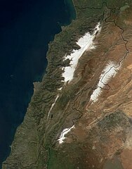
| ᱵᱤᱵᱚᱨᱚᱱᱤ | Satellite image of Lebanon in March 2002. |
| ᱢᱟᱹᱦᱤᱛ | |
| ᱯᱷᱮᱰᱟᱛ | Cropped from: http://visibleearth.nasa.gov/view_rec.php?id=2499 |
| ᱚᱱᱚᱞᱤᱭᱟᱹ | Jacques Descloitres, MODIS Land Rapid Response Team, NASA/GSFC |
| Other versions | Derivative works of this file: Jebel el gharbi in labanon satellite map.jpg |
ᱞᱟᱭᱥᱮᱱᱥ ᱛᱮᱭᱟᱨ
| This file is in the public domain in the United States because it was solely created by NASA. NASA copyright policy states that "NASA material is not protected by copyright unless noted". (See Template:PD-USGov, NASA copyright policy page or JPL Image Use Policy.) | ||
 |
Warnings:
|
ᱨᱮᱫ ᱨᱮᱭᱟᱜ ᱱᱟᱜᱟᱢ
ᱚᱠᱛᱚ ᱨᱮ ᱞᱤᱱ ᱢᱮ/ᱚᱠᱛᱚ ᱨᱮ ᱨᱮᱫ ᱧᱮᱞ ᱞᱟᱹᱜᱤᱛ ᱞᱤᱱ ᱢᱮ
| ᱢᱟᱹᱦᱤᱛ/ᱚᱠᱛᱚ | ᱴᱤᱯ | ᱡᱚᱠᱷᱟ | ᱵᱮᱵᱷᱟᱨᱤᱭᱟᱹ | ᱠᱟᱛᱷᱟ | |
|---|---|---|---|---|---|
| ᱱᱤᱛᱚᱜ | ᱑᱔:᱐᱖, ᱖ ᱡᱟᱱᱩᱣᱟᱨᱤ ᱒᱐᱐᱕ | | ᱕᱘᱔ × ᱗᱔᱔ (᱕᱙ KB) | Hautala | {{PD-USGov-NASA}} Satellite image of Lebanon in March 2002. Cropped image, original taken from NASA's Visible Earth http://visibleearth.nasa.gov/cgi-bin/viewrecord?12056 |
ᱯᱷᱟᱭᱤᱞ ᱵᱮᱣᱦᱟᱨ
ᱞᱟᱛᱟᱨ ᱨᱮᱭᱟᱜ ᱥᱟᱦᱴᱟ ᱡᱚᱱᱚᱲᱠᱚ ᱱᱤᱭᱟᱹ ᱨᱮᱫ ᱨᱮ:
ᱡᱮᱜᱮᱛ ᱡᱟᱠᱟᱛ ᱨᱮᱫ ᱵᱮᱵᱷᱟᱨᱟᱜ
ᱱᱚᱶᱟ ᱨᱮᱫᱠᱚ ᱵᱮᱵᱷᱟᱨᱟᱠᱟᱫ ᱣᱤᱠᱤᱠᱚ :
- ab.wikipedia.org ᱨᱮ ᱵᱮᱣᱦᱟᱨ
- af.wikipedia.org ᱨᱮ ᱵᱮᱣᱦᱟᱨ
- ar.wikipedia.org ᱨᱮ ᱵᱮᱣᱦᱟᱨ
- ar.wikiquote.org ᱨᱮ ᱵᱮᱣᱦᱟᱨ
- arz.wikipedia.org ᱨᱮ ᱵᱮᱣᱦᱟᱨ
- azb.wikipedia.org ᱨᱮ ᱵᱮᱣᱦᱟᱨ
- az.wikipedia.org ᱨᱮ ᱵᱮᱣᱦᱟᱨ
- ba.wikipedia.org ᱨᱮ ᱵᱮᱣᱦᱟᱨ
- be.wikipedia.org ᱨᱮ ᱵᱮᱣᱦᱟᱨ
- bg.wikipedia.org ᱨᱮ ᱵᱮᱣᱦᱟᱨ
- bn.wikipedia.org ᱨᱮ ᱵᱮᱣᱦᱟᱨ
- ca.wikipedia.org ᱨᱮ ᱵᱮᱣᱦᱟᱨ
- ceb.wikipedia.org ᱨᱮ ᱵᱮᱣᱦᱟᱨ
- ckb.wikipedia.org ᱨᱮ ᱵᱮᱣᱦᱟᱨ
- cy.wikipedia.org ᱨᱮ ᱵᱮᱣᱦᱟᱨ
- da.wikipedia.org ᱨᱮ ᱵᱮᱣᱦᱟᱨ
- de.wikipedia.org ᱨᱮ ᱵᱮᱣᱦᱟᱨ
- de.wiktionary.org ᱨᱮ ᱵᱮᱣᱦᱟᱨ
- el.wikipedia.org ᱨᱮ ᱵᱮᱣᱦᱟᱨ
- en.wikipedia.org ᱨᱮ ᱵᱮᱣᱦᱟᱨ
ᱱᱚᱶᱟ ᱨᱮᱫ ᱨᱮᱱᱟᱜ ᱵᱟᱹᱲᱛᱤ ᱡᱮᱜᱮᱛ ᱵᱮᱵᱷᱟᱨ ᱧᱮᱞ ᱢᱮ ᱾