
ᱨᱮᱫ:Mayurbhanj Midnapore border 1776.jpg

ᱧᱮᱞᱡᱚᱝ ᱨᱮᱱᱟᱜ ᱟᱠᱟᱨ:᱘᱐᱐ × ᱖᱐᱐ ᱯᱤᱠᱥᱮᱞ ᱮᱴᱟᱜ ᱨᱤᱡᱚᱞᱩᱥᱚᱱᱥ: ᱓᱒᱐ × ᱒᱔᱐ ᱯᱤᱠᱥᱮᱞ | ᱖᱔᱐ × ᱔᱘᱐ ᱯᱤᱠᱥᱮᱞ | ᱑,᱐᱒᱔ × ᱗᱖᱘ ᱯᱤᱠᱥᱮᱞ | ᱑,᱒᱘᱐ × ᱙᱖᱐ ᱯᱤᱠᱥᱮᱞ | ᱒,᱕᱖᱐ × ᱑,᱙᱒᱐ ᱯᱤᱠᱥᱮᱞ | ᱓,᱐᱒᱘ × ᱒,᱒᱗᱑ ᱯᱤᱠᱥᱮᱞ
ᱟᱥᱚᱞ ᱨᱮᱫ (᱓,᱐᱒᱘ x ᱒,᱒᱗᱑ pixels, file size: ᱑᱐.᱒᱕ MB, MIME type: image/jpeg)
ᱢᱩᱬᱩᱛ ᱠᱟᱛᱷᱟ
| ᱵᱤᱵᱚᱨᱚᱱᱤ |
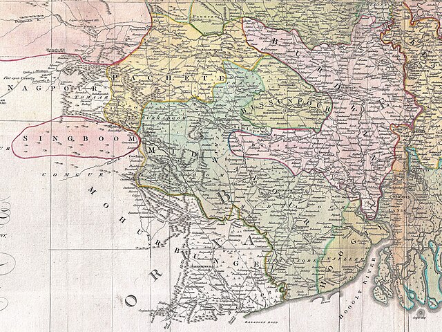
English: A cropped map of James Rennell's Bengal and Bihar showing 1776 Orissa (Mayurbhanj) and Bengal border. |
| ᱢᱟᱹᱦᱤᱛ | |
| ᱯᱷᱮᱰᱟᱛ | An actual survey of the province Bengal, Bihar & c. |
| ᱚᱱᱚᱞᱤᱭᱟᱹ | James Rennell |
| Other versions |

ᱞᱟᱭᱥᱮᱱᱥ ᱛᱮᱭᱟᱨ
|
This work is in the public domain in its country of origin and other countries and areas where the copyright term is the author's life plus 100 years or fewer. This work is in the public domain in the United States because it was published (or registered with the U.S. Copyright Office) before January 1, 1929. | |
| This file has been identified as being free of known restrictions under copyright law, including all related and neighboring rights. | |
ᱨᱮᱫ ᱨᱮᱭᱟᱜ ᱱᱟᱜᱟᱢ
ᱚᱠᱛᱚ ᱨᱮ ᱞᱤᱱ ᱢᱮ/ᱚᱠᱛᱚ ᱨᱮ ᱨᱮᱫ ᱧᱮᱞ ᱞᱟᱹᱜᱤᱛ ᱞᱤᱱ ᱢᱮ
| ᱢᱟᱹᱦᱤᱛ/ᱚᱠᱛᱚ | ᱴᱤᱯ | ᱡᱚᱠᱷᱟ | ᱵᱮᱵᱷᱟᱨᱤᱭᱟᱹ | ᱠᱟᱛᱷᱟ | |
|---|---|---|---|---|---|
| ᱱᱤᱛᱚᱜ | ᱑᱕:᱕᱒, ᱑᱗ ᱡᱩᱞᱟᱭ ᱒᱐᱒᱓ | | ᱓,᱐᱒᱘ × ᱒,᱒᱗᱑ (᱑᱐.᱒᱕ MB) | MaxA-Matrix | Better quality, clear visibility of names |
| ᱐᱗:᱒᱒, ᱑ ᱡᱩᱞᱟᱭ ᱒᱐᱒᱓ |  | ᱑,᱙᱗᱕ × ᱑,᱔᱘᱑ (᱒.᱐᱙ MB) | MaxA-Matrix | cropped 4:3 | |
| ᱑᱒:᱐᱘, ᱓᱐ ᱡᱩᱱ ᱒᱐᱒᱓ |  | ᱑,᱓᱘᱖ × ᱑,᱓᱘᱗ (᱑.᱓᱒ MB) | MaxA-Matrix | Uploaded a work by James Rennell from An actual survey of the province Bengal, Bihar & c. with UploadWizard |
ᱯᱷᱟᱭᱤᱞ ᱵᱮᱣᱦᱟᱨ
ᱞᱟᱛᱟᱨ ᱨᱮᱭᱟᱜ 2 ᱥᱟᱦᱴᱟᱠᱚ ᱡᱚᱱᱚᱲ ᱱᱤᱭᱟᱹ ᱨᱮᱫ ᱨᱮ:
ᱡᱮᱜᱮᱛ ᱡᱟᱠᱟᱛ ᱨᱮᱫ ᱵᱮᱵᱷᱟᱨᱟᱜ
ᱱᱚᱶᱟ ᱨᱮᱫᱠᱚ ᱵᱮᱵᱷᱟᱨᱟᱠᱟᱫ ᱣᱤᱠᱤᱠᱚ :