ᱵᱨᱤᱴᱤᱥ ᱨᱟᱡᱽ
| ᱥᱤᱧᱚᱛ | ||
|---|---|---|
 |
||
| ᱨᱟᱡᱽᱜᱟᱲ | ᱠᱟᱞᱠᱟᱛᱛᱟ[᱑][lower-alpha ᱑] (᱑᱘᱕᱘–᱑᱙᱑᱑) ᱱᱟᱶᱟ ᱫᱤᱞᱞᱤ (᱑᱙᱑᱑/᱑᱙᱓᱑[lower-alpha ᱒]–᱑᱙᱔᱗) | |
| ᱨᱟᱡᱽ ᱯᱟᱹᱨᱥᱤ | ᱤᱝᱞᱤᱥ ᱟᱨ ᱩᱨᱫᱩ[᱓][᱔] | |
| ᱥᱚᱨᱠᱟᱨ | ᱵᱨᱤᱴᱤᱥ ᱠᱚᱞᱚᱱᱤᱭᱟᱞ ᱥᱚᱨᱠᱟᱨ | |
| ᱞᱮᱡᱤᱥᱞᱟᱪᱚᱨ | Imperial Legislative Council | |
| ᱠᱟᱹᱣᱰᱤ | ᱥᱤᱧᱚᱛᱤᱭᱟᱹ ᱨᱩᱯᱤ | |
|
||
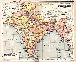
ᱵᱨᱤᱴᱤᱥ ᱨᱟᱡᱽ ᱫᱚ ᱑᱘᱕᱘ ᱟᱨ ᱑᱙᱔᱗ ᱛᱟᱞᱟ ᱨᱮ ᱥᱤᱧᱚᱛᱤᱭᱟᱹ ᱩᱯᱢᱟᱦᱟᱫᱤᱯ ᱨᱮ ᱵᱨᱤᱴᱤᱥ ᱦᱚᱛᱮᱛᱮ ᱥᱟᱥᱚᱱᱚᱜ ᱠᱟᱱ ᱛᱟᱦᱮᱸᱫ ᱾
ᱱᱟᱜᱟᱢ
[ᱥᱟᱯᱲᱟᱣ | ᱯᱷᱮᱰᱟᱛ ᱥᱟᱯᱲᱟᱣ]᱑᱘᱕᱗ ᱥᱮᱨᱢᱟ ᱨᱮᱭᱟᱜ ᱥᱤᱧᱚᱛᱤᱭᱟᱹ ᱩᱛᱱᱟᱹᱣ ᱛᱟᱭᱚᱢ ᱵᱨᱤᱴᱤᱥ ᱥᱚᱨᱠᱟᱨ ᱫᱚ ᱵᱨᱤᱴᱤᱥ ᱨᱟᱡᱽ ᱟᱜ ᱛᱷᱟᱯᱚᱱ ᱞᱟᱹᱜᱤᱫ ᱥᱚᱨᱠᱟᱨ ᱴᱷᱮᱱ ᱮ ᱥᱮᱱ ᱮᱱᱟ ᱾ ᱵᱨᱤᱴᱤᱥ ᱨᱟᱡᱽ ᱫᱚ ᱵᱨᱤᱴᱤᱥ ᱯᱟᱨᱞᱤᱭᱟᱢᱮᱱᱴ ᱑᱘᱕᱘ ᱠᱷᱚᱱ ᱑᱙᱔᱗ ᱫᱷᱟᱹᱵᱤᱡ ᱵᱨᱤᱴᱤᱥ ᱥᱟᱥᱚᱱ ᱚᱠᱛᱚ ᱠᱟᱱᱟ ᱾ ᱑᱘᱕᱘ ᱥᱮᱨᱢᱟ ᱨᱮ ᱤᱥᱴ ᱤᱱᱰᱤᱭᱟ ᱠᱚᱢᱯᱟᱱᱤ ᱭᱤᱡ ᱥᱚᱨᱠᱟᱨ ᱨᱟᱡᱟ ᱣᱤᱠᱴᱚᱨᱤᱭᱟ ᱦᱚᱛᱮᱛᱮ ᱠᱨᱳᱱᱟ ᱨᱮ ᱥᱮᱞᱮᱫ ᱞᱮᱱ ᱛᱮ ᱥᱚᱨᱠᱟᱨᱤ ᱯᱟᱥᱱᱟᱣ ᱦᱩᱭ ᱞᱮᱱᱟ ।
ᱚᱛᱱᱚᱜ ᱥᱤᱢᱟᱹ
[ᱥᱟᱯᱲᱟᱣ | ᱯᱷᱮᱰᱟᱛ ᱥᱟᱯᱲᱟᱣ]ᱵᱨᱤᱛᱟᱱᱤ ᱨᱟᱡᱽ ᱜᱳᱣᱟ ᱟᱨ ᱯᱩᱰᱩᱪᱮᱨᱤ ᱞᱮᱠᱟᱱ ᱪᱷᱟᱰᱟ ᱠᱟᱛᱮ ᱱᱤᱛᱚᱜᱟᱜ ᱚᱠᱛᱚ ᱥᱤᱧᱚᱛ, ᱯᱟᱠᱤᱥᱛᱟᱱ ᱟᱨ ᱵᱟᱝᱞᱟᱫᱮᱥ ᱫᱷᱟᱹᱵᱤᱡ ᱡᱤᱞᱤᱧ ᱚᱥᱟᱨ ᱛᱟᱦᱮᱸ ᱠᱟᱱᱟ ᱾ ᱵᱷᱤᱱᱟᱹ ᱵᱷᱤᱱᱟᱹ ᱚᱠᱛᱚ ᱨᱮ ᱱᱚᱸᱰᱮ ᱟᱫᱟᱱ ᱫᱚ (᱑᱘᱕᱘ ᱠᱷᱚᱱ ᱑᱙᱓᱗ ᱫᱷᱟᱹᱵᱤᱡ),[᱕] ᱪᱮᱛᱟᱱ ᱵᱟᱨᱢᱟ (᱑᱘᱕᱘ ᱠᱷᱚᱱ ᱑᱙᱓᱗ ᱫᱷᱟᱹᱵᱤᱡ), ᱞᱟᱛᱟᱨ ᱵᱟᱨᱢᱟ (᱑᱘᱘᱖ ᱠᱷᱚᱱ ᱑᱙᱓᱗ ᱫᱷᱟᱹᱵᱤᱡ), ᱵᱨᱤᱛᱟᱱᱤ ᱥᱳᱢᱟᱞᱤᱞᱮᱸᱰ (᱑᱘᱘᱔ ᱠᱷᱚᱱ ᱑᱘᱙᱘ ᱫᱷᱟᱹᱵᱤᱡ) ᱟᱨ ᱥᱤᱸᱜᱟᱯᱩᱨ (᱑᱘᱕᱘ ᱠᱷᱚᱱ ᱑᱘᱖᱗ ᱫᱷᱟᱹᱵᱤᱡ) ᱫᱚ ᱦᱚᱸ ᱥᱮᱞᱮᱫᱚᱜ ᱜᱮᱭᱟ ᱾
ᱠᱟᱹᱣᱰᱤ ᱟᱹᱨᱤ
[ᱥᱟᱯᱲᱟᱣ | ᱯᱷᱮᱰᱟᱛ ᱥᱟᱯᱲᱟᱣ]ᱦᱚᱲ ᱮᱞ
[ᱥᱟᱯᱲᱟᱣ | ᱯᱷᱮᱰᱟᱛ ᱥᱟᱯᱲᱟᱣ]ᱥᱮᱪᱮᱫ
[ᱥᱟᱯᱲᱟᱣ | ᱯᱷᱮᱰᱟᱛ ᱥᱟᱯᱲᱟᱣ]ᱥᱟᱹᱠᱷᱭᱟᱹᱛ
[ᱥᱟᱯᱲᱟᱣ | ᱯᱷᱮᱰᱟᱛ ᱥᱟᱯᱲᱟᱣ]- ↑ "Calcutta (ᱠᱟᱞᱤᱠᱟᱛᱟ)", The Imperial Gazetteer of India, vol. IX, Published under the Authority of His Majesty's Secretary of State for India in Council, Oxford at the Clarendon Press, 1908, p. 260,
—Capital of the Indian Empire, situated in 22° 34' N and 88° 22' E, on the east or left bank of the Hooghly river, within the Twenty-four Parganas District, Bengal
- ↑ "Simla Town", The Imperial Gazetteer of India, vol. XXII, Published under the Authority of His Majesty's Secretary of State for India in Council, Oxford at the Clarendon Press, 1908, p. 260,
—Head-quarters of Simla District, Punjab, and the summer capital of the Government of India, situated on a transverse spur of the Central Himālayan system system, in 31° 6' N and 77° 10' E, at a mean elevation above sea-level of 7,084 feet.
- ↑ Vejdani, Farzin (2015), Making History in Iran: Education, Nationalism, and Print Culture, Stanford, CA: Stanford University Press, pp. 24–25, ISBN 978-0-8047-9153-3,
Although the official languages of administration in India shifted from Persian to English and Urdu in 1837, Persian continued to be taught and read there through the early twentieth century.
- ↑ Everaert, Christine (2010), Tracing the Boundaries between Hindi and Urdu, Leiden and Boston: BRILL, pp. 253–254, ISBN 978-90-04-17731-4,
It was only in 1837 that Persian lost its position as official language of India to Urdu and to English in the higher levels of administration.
- ↑ मार्शल, पी॰जे॰ (2001), The Cambridge Illustrated History of the British Empire, 400 pp., कैम्ब्रिज और लंदन: कैम्ब्रिज यूनिवर्सिटी प्रेस, p. 384, ISBN 978-0-521-00254-7
